IMAGES TAKEN NEAR TO
Victoria Road, ST. AUSTELL, PL25 4QF
Introduction
This page details the photographs taken nearby to Victoria Road, PL25 4QF by members of the Geograph project.
The Geograph project started in 2005 with the aim of publishing, organising and preserving representative images for every square kilometre of Great Britain, Ireland and the Isle of Man.

There are currently over 7.5m images from over14,400 individuals and you can help contribute to the project by visiting https://www.geograph.org.uk
Image Map
Images are licensed for reuse under creativecommons.org/licenses/by-sa/2.0
Notes
- Clicking on the map will re-center to the selected point.
- The higher the marker number, the further away the image location is from the centre of the postcode.
Image Listing (28 Images Found)
Images are licensed for reuse under creativecommons.org/licenses/by-sa/2.0
Image
Details
Distance
3
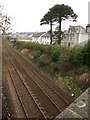
Railway line, Mount Charles
The main line to Penzance approaches St Austell station; taken from Clifden Road. The houses are on Ranelagh Road.
Image: © Derek Harper
Taken: 29 Jan 2009
0.06 miles
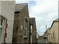
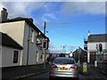
4
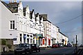
Victoria Road, Mount Charles
Terraces of three storey houses, each with a shop in the ground floor.
Image: © Tony Atkin
Taken: 12 Nov 2005
0.07 miles
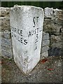
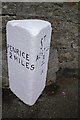
5
Old Milestone by UC road, Victoria Road, by No. 11, Mount Charles
The Milestone is located against wall on the North of the road. Parish of St Austell (Restormel District). Carved stone post, erected by the estate in the 19th Century. An earlier photograph can be found here: https://www.geograph.org.uk/photo/6432096
Inscription reads:-
PENRICE / 2 MILES : : St / AUSTLE / ¾
Grade II listed. List Entry Number: 1394421 https://historicengland.org.uk/listing/the-list/list-entry/1394421
Milestone Society National ID: CW_PCSA02
Image: © P Barnett
Taken: 13 Jun 2023
0.07 miles
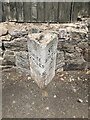
6
Old Milestone in Victoria Road, St Austell
Carved stone post by the UC road, in parish of ST AUSTELL (RESTORMEL District), Victoria Road, by No. 11, Mount Charles, half buried in pavement until 1992, on North side of road. Erected by a private estate in the 19th century.
Inscription reads:-
: PENRICE / 2 MILES : : Sᵀ / AUSTLE / ¾ :
Grade II listed.
List Entry Number: 1394421 https://historicengland.org.uk/listing/the-list/list-entry/1394421
Milestone Society National ID: CW_PCSA02.
Image: © Rosy Hanns
Taken: 7 Apr 2019
0.08 miles
7
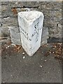
Old Milestone by Victoria Road, Mount Charles, St Austell
Carved stone post by the UC road, in parish of ST AUSTELL (RESTORMEL District), Victoria Road, by No.11, Mount Charles, half buried in pavement until 1992, on North side of road. Erected by a private estate in the 19th century.
Inscription reads:-
: PENRICE / 2 MILES : : ST / AUSTLE / 3/4 :
Grade II listed. List Entry Number: 1394421
Milestone Society National ID: CW_PCSA02.
Image: © Paul Barnett
Taken: 19 Jul 2018
0.09 miles
9
Old Milestone by Victoria Road, Mount Charles, St Austell
Carved stone post by the UC road, in parish of ST AUSTELL (RESTORMEL District), Victoria Road, by No.11, Mount Charles, half buried in pavement until 1992, on North side of road. Erected by a private estate in the 19th century.
Inscription reads:-
: PENRICE / 2 MILES : : ST / AUSTLE / 3/4 :
Grade II listed. List Entry Number: 1394421
https://historicengland.org.uk/listing/the-list/list-entry/1394421
Milestone Society National ID: CW_PCSA02.
Image: © Ian Thompson
Taken: Unknown
0.09 miles