IMAGES TAKEN NEAR TO
Church Street, ST. AUSTELL, PL25 4FZ
Introduction
This page details the photographs taken nearby to Church Street, PL25 4FZ by members of the Geograph project.
The Geograph project started in 2005 with the aim of publishing, organising and preserving representative images for every square kilometre of Great Britain, Ireland and the Isle of Man.

There are currently over 7.5m images from over14,400 individuals and you can help contribute to the project by visiting https://www.geograph.org.uk
Image Map (Loading...)


Getting Data...Please wait
Leaflet Map data © OpenStreetMap
Images are licensed for reuse under creativecommons.org/licenses/by-sa/2.0
Notes
- Clicking on the map will re-center to the selected point.
- The higher the marker number, the further away the image location is from the centre of the postcode.
Image Listing (239 Images Found)
Images are licensed for reuse under creativecommons.org/licenses/by-sa/2.0
Image
Details
Distance
1
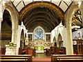
Holy Trinity church, St Austell, chancel
The church is listed grade I (list entry 1211925) and the chancel is 14th century in origin, though heavily restored by G E Street in 1872. Although not mentioned in the listing, many of the fittings are by George Fellowes Prynne, see https://www.gfp.sharville.org.uk/more/StAustell-HolyTrinity.htm
Image: © Stephen Craven
Taken: 10 Aug 2018
0.00 miles
2
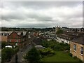
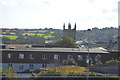
St. Austell, viewed from the bus station
Image: © A J Paxton
Taken: 24 Jun 2021
0.01 miles
3
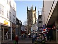
Fore Street and St Austell Church
Looking along the street at the start of Saturday morning shopping towards the church. Note the sculptures set into the church tower. See Image for a detailed view.
Image: © Tony Atkin
Taken: 12 Nov 2005
0.01 miles
4
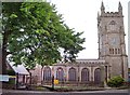
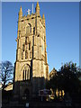
Holy Trinity Church, St Austell
The church was originally dedicated to St Austol, a Breton saint associated with St Meven, but is now dedicated to the Holy Trinity. By 1150 it had been appropriated to the Priory of Tywardreath and this continued until 1535. The present 15th century church is faced in Pentewan stone and the tower can be dated to between 1478 and 1487 by the arms of Bishop Courtenay.
Image: © Len Williams
Taken: 26 Jun 2012
0.01 miles
6
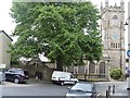
Church, memorial and tree
The fine tree partly obscures the parish church of the Holy Trinity. The church is mostly 15th century with some 13th and 14th century parts. Listed, grade I, with details at: https://www.historicengland.org.uk/listing/the-list/list-entry/1211925
The war memorial, an intricately carved Celtic cross, is listed, grade II, with details at: https://www.historicengland.org.uk/listing/the-list/list-entry/1421321
Image: © Michael Dibb
Taken: 3 Jun 2017
0.01 miles
7
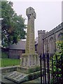
War Memorial, St Austell
The War Memorial, which takes the shape of a Celtic Cross is situated next to the parish church of The Holy Trinity.
Image: © Len Williams
Taken: 26 Jun 2012
0.01 miles
8
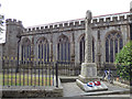
St Austell, war memorial
The memorial is at the roadside outside the parish church of the Holy Trinity. It is listed grade II (list entry 1421321).
The inscription on the main base of the memorial is
"To the Glory of God and in sacred memory of the men of the ancient Parish of St Austell who made the supreme sacrifice in the Great War 1914-1918."
The memorial was erected in the 1920s but it was not until 1991 that the names of the victims of WW2 were added to the sloping part of the base, with the inscription “and in memory of those of this area who lost their lives in the war of 1939-1945”.
Image: © Stephen Craven
Taken: 10 Aug 2018
0.01 miles
9
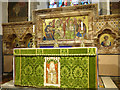
Holy Trinity church, St Austell, high altar and reredos
The church is listed grade I (list entry 1211925) and the reredos mosaic is by G E Street, 1872.
Image: © Stephen Craven
Taken: 10 Aug 2018
0.01 miles
10
Holy Trinity Church
Grade I listed. https://www.britishlistedbuildings.co.uk/101211925-holy-trinity-church-st-austell
Image: © N Chadwick
Taken: 1 Sep 2017
0.01 miles