IMAGES TAKEN NEAR TO
Polmear Parc, PAR, PL24 2AA
Introduction
This page details the photographs taken nearby to Polmear Parc, PL24 2AA by members of the Geograph project.
The Geograph project started in 2005 with the aim of publishing, organising and preserving representative images for every square kilometre of Great Britain, Ireland and the Isle of Man.

There are currently over 7.5m images from over14,400 individuals and you can help contribute to the project by visiting https://www.geograph.org.uk
Image Map (Loading...)


Getting Data...Please wait
Leaflet Map data © OpenStreetMap
Images are licensed for reuse under creativecommons.org/licenses/by-sa/2.0
Notes
- Clicking on the map will re-center to the selected point.
- The higher the marker number, the further away the image location is from the centre of the postcode.
Image Listing (36 Images Found)
Images are licensed for reuse under creativecommons.org/licenses/by-sa/2.0
Image
Details
Distance
1
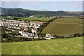
Polmear
Modern suburban housing lines the hillside beyond the double hedgerow which marks a narrow lane going over the hill to Tywardreath.
Image: © Tony Atkin
Taken: 15 Sep 2007
0.04 miles
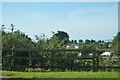


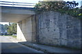
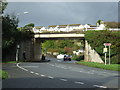
8
Bridge over the A3082, Polmear
Was once a railway, now used as a private road for china clay transport.
Image: © JThomas
Taken: 7 Nov 2014
0.17 miles
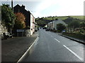
9

The Royal Massala Asian Restaurant, Polmear
Almost opposite the 'Ship Inn'
Image: © Dr Neil Clifton
Taken: 1 Apr 2009
0.17 miles
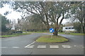
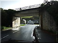
10
Bridge over the A3082, Polmear
Was once a railway, now used as a private road for china clay transport.
Image: © JThomas
Taken: 7 Nov 2014
0.17 miles