IMAGES TAKEN NEAR TO
Hanson Drive, FOWEY, PL23 1ET
Introduction
This page details the photographs taken nearby to Hanson Drive, PL23 1ET by members of the Geograph project.
The Geograph project started in 2005 with the aim of publishing, organising and preserving representative images for every square kilometre of Great Britain, Ireland and the Isle of Man.

There are currently over 7.5m images from over14,400 individuals and you can help contribute to the project by visiting https://www.geograph.org.uk
Image Map
Images are licensed for reuse under creativecommons.org/licenses/by-sa/2.0
Notes
- Clicking on the map will re-center to the selected point.
- The higher the marker number, the further away the image location is from the centre of the postcode.
Image Listing (92 Images Found)
Images are licensed for reuse under creativecommons.org/licenses/by-sa/2.0
Image
Details
Distance
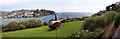
1
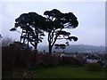
Evening view of a front garden above Fowey
Polruan can be seen in the background.
Image: © Ruth Sharville
Taken: 22 Mar 2012
0.07 miles
4
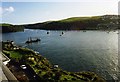
Fowey riverbank and estuary from Esplanade
Image: © David Gearing
Taken: Unknown
0.09 miles
5
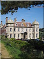
Fowey Hall hotel
Built in 1899 by Sir Charles Hanson, a former Lord Mayor of London, Fowey Hall regularly hosted royal visitors and it was the inspiration for Toad Hall in 'The Wind in the Willows'. It is now a luxury family hotel and every May hosts the Daphne Du Maurier literary festival.
Image: © Rod Allday
Taken: 12 May 2008
0.10 miles
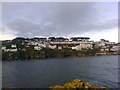
6
River Fowey Estuary
A view from the road to Readymoney overlooking the Fowey estuary towards the town of Polruan. Not everybody has to navigate the narrow streets to get out of the town !
Image: © Len Williams
Taken: 28 Jun 2012
0.10 miles
7
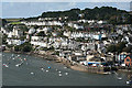
Fowey from the Hall Walk
Seen from across the harbour. The tall cream-washed building on the left is the Fowey Hotel. On the right, foreground, is the Town Quay, with the passenger ferry to Polruan. The blue-washed building nearby is the King of Prussia inn
Image: © Martin Bodman
Taken: 6 Oct 2010
0.10 miles
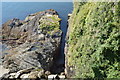
9
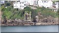
Ruin of the Fowey blockhouse, seen from the Polruan blockhouse
Blockhouses were primitive coastal defence mechanisms, used primarily against pirates and other sea raiders in the Middle Ages. A chain was stretched between two towers, one on each side of a river or estuary and raised or lowered as necessary to block or permit passage along the river. The pair of blockhouses at Fowey and Polruan were intended to guard the estuary of the River Fowey. The Western or Fowey blockhouse, seen here, is but a shell, but the eastern or Polruan blockhouse, from which the picture was taken, is in a much better state of preservation.
Image: © Nigel Wassell
Taken: 17 Sep 2019
0.10 miles
10
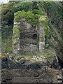
Fowey - Remains of blockhouse from Polruan blockhouse
The entrance to Fowey harbour was guarded by two blockhouses one in Polruan which is still in quite good condition (though an empty shell) and the other, far more ruinous, on the Fowey side - seen here.
A very heavy chain was slung between the two - normally well below the waterline. But in the event of attack this chain could be raised to effectively seal the entrance.
Image: © Rob Farrow
Taken: 7 Oct 2021
0.11 miles