IMAGES TAKEN NEAR TO
LOSTWITHIEL, PL22 0RD
Introduction
This page details the photographs taken nearby to PL22 0RD by members of the Geograph project.
The Geograph project started in 2005 with the aim of publishing, organising and preserving representative images for every square kilometre of Great Britain, Ireland and the Isle of Man.

There are currently over 7.5m images from over14,400 individuals and you can help contribute to the project by visiting https://www.geograph.org.uk
Image Map
Images are licensed for reuse under creativecommons.org/licenses/by-sa/2.0
Notes
- Clicking on the map will re-center to the selected point.
- The higher the marker number, the further away the image location is from the centre of the postcode.
Image Listing (19 Images Found)
Images are licensed for reuse under creativecommons.org/licenses/by-sa/2.0
Image
Details
Distance
2
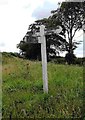
Direction Sign ? Signpost
Located on a grass triangle in the centre of a Y junction near Higher Hartswell Farm in St Winnow parish. 3 arms and no finial. See also https://www.geograph.org.uk/photo/1870127.
Milestone Society National ID: CW_SX1260
Image: © R Fleet
Taken: 28 Jul 2019
0.04 miles
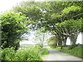
3
Road to Higher Hartswell Farm and woodland beyond
Image: © David Smith
Taken: 6 Jul 2021
0.05 miles
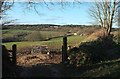
4
Towards Higher Hartswell Farm
From the gateway shown in Image], again with animal feeder. More of the farm can be seen here. This area is part of the site of the Battle of Lostwithiel on 21 August 1644 https://www.historicengland.org.uk/listing/the-list/list-entry/1413619 . "While the agricultural land management has changed since the battle, the battlefield area remains largely undeveloped and permits the course of the battles to be appreciated."
Image: © Derek Harper
Taken: 31 Mar 2016
0.09 miles
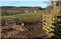
5
Field, Hartswell
A gateway from the lane shown in Image Buildings at Higher Hartswell Farm can be seen on the right. Behind is woodland on Druid's Hill. This area is part of the site of the Battle of Lostwithiel on 21 August 1644 https://www.historicengland.org.uk/listing/the-list/list-entry/1413619 . "While the agricultural land management has changed since the battle, the battlefield area remains largely undeveloped and permits the course of the battles to be appreciated."
Image: © Derek Harper
Taken: 31 Mar 2016
0.17 miles
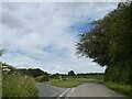
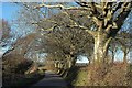
6
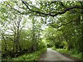
Minor road north-east of Hartswell
To the west (left) the land slopes down steeply
Image: © David Smith
Taken: 6 Jul 2021
0.18 miles
7
Trees near Hartswell
Trees along a bank by the lane to Higher Hartswell Farm. The photos at http://www.geograph.org.uk/search.php?i=64217098 were taken from the gate on the left and show part of the site of the Battle of Lostwithiel on 21 August 1644 https://www.historicengland.org.uk/listing/the-list/list-entry/1413619 .
Image: © Derek Harper
Taken: 31 Mar 2016
0.18 miles
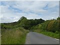
9
Woodland north of Higher Hartswell Farm
The woodland is part of the Boconnoc estate to the east
Image: © David Smith
Taken: 6 Jul 2021
0.20 miles