IMAGES TAKEN NEAR TO
Downend, LOSTWITHIEL, PL22 0RB
Introduction
This page details the photographs taken nearby to PL22 0RB by members of the Geograph project.
The Geograph project started in 2005 with the aim of publishing, organising and preserving representative images for every square kilometre of Great Britain, Ireland and the Isle of Man.

There are currently over 7.5m images from over14,400 individuals and you can help contribute to the project by visiting https://www.geograph.org.uk
Image Map (Loading...)


Getting Data...Please wait
Leaflet Map data © OpenStreetMap
Images are licensed for reuse under creativecommons.org/licenses/by-sa/2.0
Notes
- Clicking on the map will re-center to the selected point.
- The higher the marker number, the further away the image location is from the centre of the postcode.
Image Listing (10 Images Found)
Images are licensed for reuse under creativecommons.org/licenses/by-sa/2.0
Image
Details
Distance
1
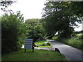
Entrance to Hartswell
A B&B, Self-catering and Livery business.
Image: © Jonathan Billinger
Taken: 11 Jul 2007
0.06 miles
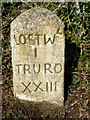
3

Old Milestone by the A390, Sandylake, Lostwithiel parish
Carved stone post by the A390, in parish of LOSTWITHIEL (RESTORMEL District), Sandylake, by the West side of road. St Austell Roman stone, erected by the St Austell & Lostwithiel turnpike trust in the 18th century.
Inscription reads:-
LOSTWL
I
TRURO
XXIII
Grade II listed.
List Entry Number: 1137859 https://historicengland.org.uk/listing/the-list/list-entry/1137859
Milestone Society National ID: CW_LSTO01.
Image: © Ian Thompson
Taken: Unknown
0.18 miles
4
Old Milestone by the A390, Sandylake, north east of Lostwithiel
Carved stone post by the A390, in parish of LOSTWITHIEL (RESTORMEL District), Sandylake, by the road. St Austell Roman stone, erected by the St Austell & Lostwithiel turnpike trust in the 18th century.
Inscription reads:-
LOSTWL
I
TRURO
XXIII
Grade II listed.
List Entry Number: 1137859 https://historicengland.org.uk/listing/the-list/list-entry/1137859
Milestone Society National ID: CW_LSTO01.
Image: © Rosy Hanns
Taken: 5 Apr 2019
0.18 miles
5
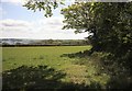
Field by the A390
The view through the gate shown in Image Across the field is just a line of trees rather than a wood.
Image: © Derek Harper
Taken: 31 Mar 2016
0.21 miles
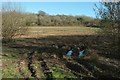
6
Farmland, Hartswell
Looking to the left from the same gateway as Image This area is part of the site of the Battle of Lostwithiel on 21 August 1644 https://www.historicengland.org.uk/listing/the-list/list-entry/1413619 . "While the agricultural land management has changed since the battle, the battlefield area remains largely undeveloped and permits the course of the battles to be appreciated."
Image: © Derek Harper
Taken: 31 Mar 2016
0.22 miles
7

Direction Sign ? Signpost
Located on the west side of a T junction west of Lostwithiel, beside a path to St Nectan's Chapel in St Winnow parish. 3 arms, 1 missing, and no finial.
Milestone Society National ID: CW_SX1259
Image: © R Fleet
Taken: 29 Jul 2019
0.23 miles
8
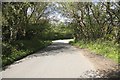
Down the lane nr Lostwithiel
There is a sawmills on the left and this rural road leads onto the main Liskeard to Lostwithiel road not far around the corner on the right. Note the bluebells are out
Image: © roger geach
Taken: 17 May 2010
0.23 miles
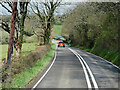
9
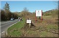
By the A390
At the junction with Two Trees Road. Signs direct you to Boconnoc up the main road, and Duchy Timber down the side road.
Image: © Derek Harper
Taken: 31 Mar 2016
0.24 miles
10
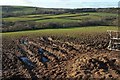
Fields at Beacon Hill Lostwithiel
Looking across the field in the distance is some smoke coming from the saw mills.
Image: © roger geach
Taken: 17 May 2010
0.25 miles