IMAGES TAKEN NEAR TO
Lerryn View, LOSTWITHIEL, PL22 0QL
Introduction
This page details the photographs taken nearby to Lerryn View, PL22 0QL by members of the Geograph project.
The Geograph project started in 2005 with the aim of publishing, organising and preserving representative images for every square kilometre of Great Britain, Ireland and the Isle of Man.

There are currently over 7.5m images from over14,400 individuals and you can help contribute to the project by visiting https://www.geograph.org.uk
Image Map
Images are licensed for reuse under creativecommons.org/licenses/by-sa/2.0
Notes
- Clicking on the map will re-center to the selected point.
- The higher the marker number, the further away the image location is from the centre of the postcode.
Image Listing (60 Images Found)
Images are licensed for reuse under creativecommons.org/licenses/by-sa/2.0
Image
Details
Distance
2
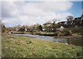
Stepping stones across the River Lerryn from the St Winnow side
The bridge is in the background. Lerryn is one of those places that grew up at a river crossing where the river is the parish boundary, so half the village is in St Veep and half in St Winnow.
Image: © Humphrey Bolton
Taken: 8 Sep 2001
0.10 miles
3
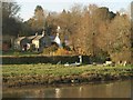
Cottages at Lerryn
A detail of the scene in Image, looking across the river. Yonder Cottage, formed of 2 cottages and a coopers, is dated 1860 and listed http://www.britishlistedbuildings.co.uk/en-60649-yonder-cot-st-winnow .
Image: © Derek Harper
Taken: 6 Mar 2011
0.10 miles
4
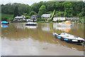
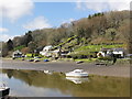
Tidal creek at Lerryn
The river creek from the Fowey is navigable at high tide up to Lerryn. This view is taken from the village green on the St Veep parish side looking across to the St Winnow parish bank. The woodland above the houses is on the edge of National Trust Land and is part of Ethy Wood.
Image: © Kate Jewell
Taken: 13 May 2007
0.10 miles
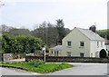
5
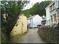
Houses on the north of the river in Lerryn
In a small, un-named, street running parallel to the river.
Image: © Rod Allday
Taken: 17 May 2011
0.11 miles
6
Lerryn, the Northern Side of the Creek
Looking across the creek at Lerryn from the waterside near the car park.
Image: © Tony Atkin
Taken: 20 Apr 2013
0.11 miles
7
The north bank of the River Lerryn
Looking across the river to the area known as Lowertown, with the Red Store Image on the left of the photo.
Image: © Rod Allday
Taken: 17 May 2011
0.13 miles
8
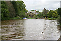
River Lerryn at high tide
Taken from the car park in the centre of this picturesque village. The river is tidal up to the bridge in Image
Image: © Kate Jewell
Taken: 13 May 2007
0.13 miles
10
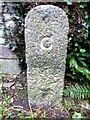
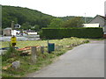
Old Boundary Marker
County Bridge Marker on the southeast side of the lane that runs parallel to and north of the River Lerryn in Lerryn village. St Winnow parish. Inscribed C. The stone marks the extent of roadway adjoining the bridge that the County was obliged to maintain.
Milestone Society National ID: CW_WINNOW01br
Image: © R Hanns
Taken: 5 Oct 2019
0.14 miles