IMAGES TAKEN NEAR TO
Lanwithan Road, LOSTWITHIEL, PL22 0ES
Introduction
This page details the photographs taken nearby to Lanwithan Road, PL22 0ES by members of the Geograph project.
The Geograph project started in 2005 with the aim of publishing, organising and preserving representative images for every square kilometre of Great Britain, Ireland and the Isle of Man.

There are currently over 7.5m images from over14,400 individuals and you can help contribute to the project by visiting https://www.geograph.org.uk
Image Map
Images are licensed for reuse under creativecommons.org/licenses/by-sa/2.0
Notes
- Clicking on the map will re-center to the selected point.
- The higher the marker number, the further away the image location is from the centre of the postcode.
Image Listing (89 Images Found)
Images are licensed for reuse under creativecommons.org/licenses/by-sa/2.0
Image
Details
Distance
1
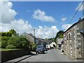
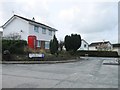
Grenville Road, Bridgend, Lostwithiel
Opposite the Land Rover is the former Methodist chapel
Image: © David Smith
Taken: 6 Jul 2021
0.04 miles
3
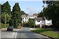
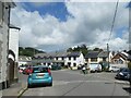
Suburban Housing, Lostwithiel
This is an area of Lostwithiel known as Bridgend (on the map). It is east of the River Fowey.
Image: © Tony Atkin
Taken: 10 Aug 2006
0.04 miles
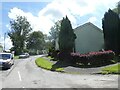
6
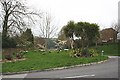
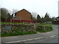
Ornamental Roadside Shrubs
On a dull and drizzly morning.
Image: © Tony Atkin
Taken: 14 Apr 2006
0.10 miles
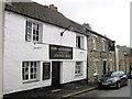
7
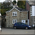
Tollhouse by Grenville Road, Lostwithiel
In the parish of Lostwithiel (Restormel District), The Old Toll House, No. 1, Grenville Road, just East of the Peace Memorial PL22.
Grade II listed.
List Entry Number: 1327320 https://historicengland.org.uk/listing/the-list/list-entry/1327320
Surveyed
Milestone Society National ID: CW.LOS
Image: © Alan Rosevear
Taken: 18 Oct 2008
0.13 miles
9
Play area at Pendour Park
A 1980's development on the eastern edge of Lostwithiel.
Image: © Jonathan Billinger
Taken: 2 Apr 2008
0.15 miles
10
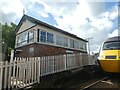
Signal box. Lostwithiel railway station
Image: © David Smith
Taken: 6 Jul 2021
0.17 miles