IMAGES TAKEN NEAR TO
Edgcumbe Road, LOSTWITHIEL, PL22 0DZ
Introduction
This page details the photographs taken nearby to Edgcumbe Road, PL22 0DZ by members of the Geograph project.
The Geograph project started in 2005 with the aim of publishing, organising and preserving representative images for every square kilometre of Great Britain, Ireland and the Isle of Man.

There are currently over 7.5m images from over14,400 individuals and you can help contribute to the project by visiting https://www.geograph.org.uk
Image Map
Images are licensed for reuse under creativecommons.org/licenses/by-sa/2.0
Notes
- Clicking on the map will re-center to the selected point.
- The higher the marker number, the further away the image location is from the centre of the postcode.
Image Listing (20 Images Found)
Images are licensed for reuse under creativecommons.org/licenses/by-sa/2.0
Image
Details
Distance
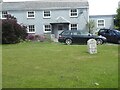
2
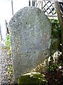
Old Wayside Cross at No Man's Land
Crewel Cross, a Wayside Cross with an old head and shaft. Set on a large grassed area outside the cottages on the A390 Edgecumbe Road, No Man's Land, near the junction with the B3269, in Lostwithiel parish. Grade II Listed https://historicengland.org.uk/listing/the-list/list-entry/1137855. See also https://www.geograph.org.uk/photo/7709712 , https://www.geograph.org.uk/photo/1128888, http://www.flickr.com/photos/tollhouses/3038274481 and http://www.flickr.com/photos/ocifant/5722171388.
Milestone Society National ID: CWRE_LOS
Image: © A Rosevear
Taken: 17 Nov 2008
0.02 miles
3
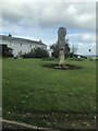
Old Wayside Cross at No Man's Land
Crewel Cross, a Wayside Cross with an old head and shaft. Set on a large grassed area outside the cottages on the A390 Edgecumbe Road, No Man's Land, near the junction with the B3269, in Lostwithiel parish. Grade II Listed https://historicengland.org.uk/listing/the-list/list-entry/1137855. See also https://www.geograph.org.uk/photo/6737349.
Milestone Society National ID: CWRE_LOS
Image: © P Barnett
Taken: 16 Feb 2024
0.02 miles
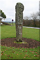
4
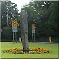
Standing stone (menhir) at No Man's Land
Situated at the A390/B3269 junction at No Man's Land, west of Lostwithiel.
Image: © Jonathan Billinger
Taken: 21 Jan 2009
0.02 miles
5
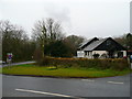
Pelyn Veterinery Clinic
Situated at the A390/B3269 junction at No Man's Land, west of Lostwithiel.
Image: © Jonathan Billinger
Taken: 21 Jan 2009
0.02 miles
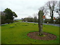
6
Old Milestone by the B3269 junction with the A390
Carved stone post by the B3269, in parish of LOSTWITHIEL (RESTORMEL District), Pelyn, Edgecombe Road, Crewell, by cottages in front of large grassed area near junction and Wayside Cross, on North side of road. Bodmin 'B' Gravestone, erected by the Bodmin turnpike trust in the 18th century.
Inscription once read:-
5
B
Milestone Society National ID: CW_BMLS05.
Image: © Rosy Hanns
Taken: 7 Apr 2019
0.02 miles
8
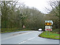
A390 at No Man's Land
The A390/B3269 junction at No Man's Land, west of Lostwithiel.
Image: © Jonathan Billinger
Taken: 21 Jan 2009
0.03 miles
9
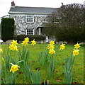
Daffodils and cottage at No Man's Land
My first daffodil pic of 2009 and of course it's in Cornwall!
The scene is hard by the A390 to the west of Lostwithiel.
Image: © Jonathan Billinger
Taken: 21 Jan 2009
0.03 miles
10
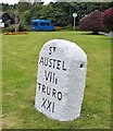
Old milestone by the A390 at No Man's Land
Carved stone post by the A390, in parish of LOSTWITHIEL (RESTORMEL District), Pelyn, Edgecombe Road, Crewell, on large grassed area near junction and Wayside Cross, outside cottages, on North side of road. St Austell Roman stone, erected by the St Austell & Lostwithiel turnpike trust in the 18th century.
Inscription reads:-
ST
AUSTEL
VIIi
TRURO
XXI
Carved benchmark on base.
Grade II Listed. List Entry Number:1327330
https://historicengland.org.uk/listing/the-list/list-entry/1327330
Milestone Society National ID: CW_TOSA21
Image: © Ian Thompson
Taken: Unknown
0.03 miles