IMAGES TAKEN NEAR TO
Lower Brook Park, IVYBRIDGE, PL21 9TZ
Introduction
This page details the photographs taken nearby to Lower Brook Park, PL21 9TZ by members of the Geograph project.
The Geograph project started in 2005 with the aim of publishing, organising and preserving representative images for every square kilometre of Great Britain, Ireland and the Isle of Man.

There are currently over 7.5m images from over14,400 individuals and you can help contribute to the project by visiting https://www.geograph.org.uk
Image Map
Images are licensed for reuse under creativecommons.org/licenses/by-sa/2.0
Notes
- Clicking on the map will re-center to the selected point.
- The higher the marker number, the further away the image location is from the centre of the postcode.
Image Listing (32 Images Found)
Images are licensed for reuse under creativecommons.org/licenses/by-sa/2.0
Image
Details
Distance
1
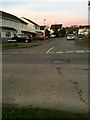
Road Junction
The junction of Woolms Meadow with Cornwood Road.
Image: © jeff collins
Taken: 5 Apr 2020
0.07 miles
2
Pedestrianised section of Woodland Rd
This short section was Pedestrianised many years ago. Only a couple of hundred metres in length.
Image: © jeff collins
Taken: 8 May 2020
0.07 miles
3
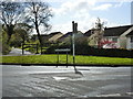
Road junction on the outskirts of Ivybridge
Woodland road meets Cornwood Road. But the crossroads has been blocked off, splitting Woodland Road into two sections in the village.
Image: © Ruth Sharville
Taken: 22 Apr 2012
0.07 miles
4
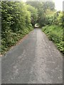
Track along Woodland Road, Ivybridge
The development of housing around Woodland Farm has led to the creation of a new road skirting the edge of the estate. To prevent through traffic from going through the estate, the old road has been closed to leave a foot and cycle-path
Image: © David Smith
Taken: 19 Dec 2015
0.08 miles
5
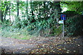
The start of Gipsy Lane off Woodland Road
This is the start of Gipsy Lane down to the A38, no longer drivable just a footpath now.
Image: © jeff collins
Taken: 14 Sep 2013
0.08 miles
6
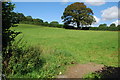
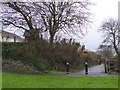
Pasture Land
Just off Cornwood Road on Woodland Road leading to St Austin`s Priory.
Image: © jeff collins
Taken: 14 Sep 2013
0.08 miles
7
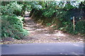
Stibb Lane
An unmetaled road eventually comes out on the minor road leading to Cornwood.
Image: © jeff collins
Taken: 14 Sep 2013
0.09 miles
8
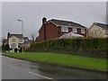
Houses at the end of Holtwood Drive, seen from Cornwood Road
Part of a housing estate on the western edge of Ivybridge
Image: © David Smith
Taken: 19 Dec 2015
0.11 miles
9
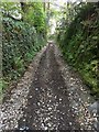
Stibb Lane
Just off Woodland Rd. Looks like a sunken lane, with stone walling both sides.
Image: © jeff collins
Taken: 19 Apr 2020
0.12 miles
10
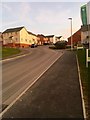
New residential housing
Just off Cornwood Road.
Image: © jeff collins
Taken: 5 Apr 2020
0.13 miles