IMAGES TAKEN NEAR TO
Cornwood, IVYBRIDGE, PL21 9RD
Introduction
This page details the photographs taken nearby to PL21 9RD by members of the Geograph project.
The Geograph project started in 2005 with the aim of publishing, organising and preserving representative images for every square kilometre of Great Britain, Ireland and the Isle of Man.

There are currently over 7.5m images from over14,400 individuals and you can help contribute to the project by visiting https://www.geograph.org.uk
Image Map
Images are licensed for reuse under creativecommons.org/licenses/by-sa/2.0
Notes
- Clicking on the map will re-center to the selected point.
- The higher the marker number, the further away the image location is from the centre of the postcode.
Image Listing (7 Images Found)
Images are licensed for reuse under creativecommons.org/licenses/by-sa/2.0
Image
Details
Distance
1

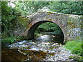
Mill Bridge
On the minor road from Hele Cross to Tor. The river just visible through the trees is the Yealm. Wisdome Bridge is a little further down stream on the minor road from Cornwood to Tor.
Image: © jeff collins
Taken: 25 Jun 2014
0.05 miles
2
Wisdome Mill Bridge
The River Yealm flowing under this old bridge beside Wisdome Mill, northeast of Cornwood.
Image: © Derek Harper
Taken: 3 Sep 2006
0.06 miles
3

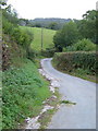
Hele Cross
The track left goes up to North Hele Farm, the minor road swings round right towards Tor.
Image: © jeff collins
Taken: 25 Jun 2014
0.17 miles
4
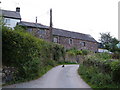
Hele
The outbuildings of North Hele (farm) are just visible top left. Hele Cross, where the farm track turns off, is just round the corner. Taken from outside South Hele (farm). Hele, meaning corner (Anglo-Saxon), is a common Devon place name.
Image: © Derek Harper
Taken: 3 Sep 2006
0.18 miles
6
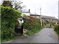
Tor Farm
From the road junction in a small hamlet spelt Tor on the 6" and older maps, and Torr on smaller scales.
Image: © Derek Harper
Taken: 3 Sep 2006
0.23 miles
7
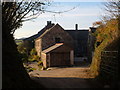
Tor Farm
At the hamlet of Tor in the parish of Cornwood; seen from the lane to Hall Cross.
Image: © Derek Harper
Taken: 5 Nov 2006
0.24 miles