IMAGES TAKEN NEAR TO
Old Way, PL21 0WN
Introduction
This page details the photographs taken nearby to Old Way, PL21 0WN by members of the Geograph project.
The Geograph project started in 2005 with the aim of publishing, organising and preserving representative images for every square kilometre of Great Britain, Ireland and the Isle of Man.

There are currently over 7.5m images from over14,400 individuals and you can help contribute to the project by visiting https://www.geograph.org.uk
Image Map
Images are licensed for reuse under creativecommons.org/licenses/by-sa/2.0
Notes
- Clicking on the map will re-center to the selected point.
- The higher the marker number, the further away the image location is from the centre of the postcode.
Image Listing (36 Images Found)
Images are licensed for reuse under creativecommons.org/licenses/by-sa/2.0
Image
Details
Distance
1
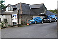
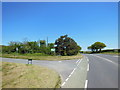
Entrance to small business units
Not far from Davey`s Cross.
Image: © jeff collins
Taken: 18 Sep 2013
0.07 miles
2
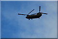
Chinook Helicopter
This Helicopter passed over me on way to North Filham.
Image: © jeff collins
Taken: 18 Sep 2013
0.09 miles

4
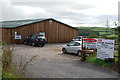
Equestrian Centre
On Davids lane near North Filham.
Image: © jeff collins
Taken: 18 Sep 2013
0.10 miles
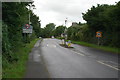
5
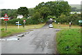
Davey`s Cross
On the B3213 just outside North Filham.
Image: © jeff collins
Taken: 18 Sep 2013
0.10 miles
7
Davey's Cross where Davids Lane crosses B3213
Image: © David Smith
Taken: 29 Feb 2012
0.10 miles
8
Davey's Cross, east of Ivybridge
The road on the left is David's Lane (not Davey's)
Image: © David Smith
Taken: 19 Mar 2014
0.11 miles
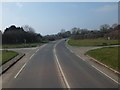
9

B3213 east of Ivybridge
This was formerly the A38, running along the lower slope of Western Beacon on Dartmoor
Image: © David Smith
Taken: 19 Mar 2014
0.12 miles
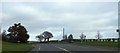
10
North Filham
On the B3213 on the outskirts of Ivybridge.
Image: © jeff collins
Taken: 18 Sep 2013
0.13 miles