IMAGES TAKEN NEAR TO
Modbury, IVYBRIDGE, PL21 0SF
Introduction
This page details the photographs taken nearby to PL21 0SF by members of the Geograph project.
The Geograph project started in 2005 with the aim of publishing, organising and preserving representative images for every square kilometre of Great Britain, Ireland and the Isle of Man.

There are currently over 7.5m images from over14,400 individuals and you can help contribute to the project by visiting https://www.geograph.org.uk
Image Map
Images are licensed for reuse under creativecommons.org/licenses/by-sa/2.0
Notes
- Clicking on the map will re-center to the selected point.
- The higher the marker number, the further away the image location is from the centre of the postcode.
Image Listing (2 Images Found)
Images are licensed for reuse under creativecommons.org/licenses/by-sa/2.0
Image
Details
Distance
1
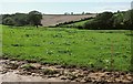
Farmland near Lixton
From the lane to Langdon Cross. A stream follows the field boundary on the right; its valley can be seen further down its course in Image
Image: © Derek Harper
Taken: 27 Aug 2015
0.24 miles
2
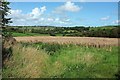
Farmland near Lixton
From the same place as Image], with a view over the valley shown in Image Farms at Chillaton and Lixton can be seen.
Image: © Derek Harper
Taken: 27 Aug 2015
0.25 miles