IMAGES TAKEN NEAR TO
The Square, IVYBRIDGE, PL21 0NT
Introduction
This page details the photographs taken nearby to The Square, PL21 0NT by members of the Geograph project.
The Geograph project started in 2005 with the aim of publishing, organising and preserving representative images for every square kilometre of Great Britain, Ireland and the Isle of Man.

There are currently over 7.5m images from over14,400 individuals and you can help contribute to the project by visiting https://www.geograph.org.uk
Image Map (Loading...)


Getting Data...Please wait
Leaflet Map data © OpenStreetMap
Images are licensed for reuse under creativecommons.org/licenses/by-sa/2.0
Notes
- Clicking on the map will re-center to the selected point.
- The higher the marker number, the further away the image location is from the centre of the postcode.
Image Listing (43 Images Found)
Images are licensed for reuse under creativecommons.org/licenses/by-sa/2.0
Image
Details
Distance
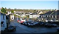
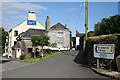
2
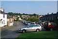
The square, Ugborough
Houses along the eastern side of the square include the post office. Lutterburn Street enters from the left.
Image: © Derek Harper
Taken: 29 Aug 2006
0.01 miles
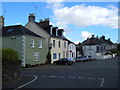
3
Lutterburn Street, Ugborough
The street leaves the north end of the village square, heading ENE down to cross a stream, past the Anchor Inn, seen on the left. Anchor Inn, Ship Inn - clearly Ugborough, nearly 10 miles from the nearest port, has had a great affinity for the sea.
Image: © Derek Harper
Taken: 29 Aug 2006
0.02 miles
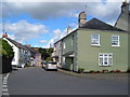
4
Ugborough: The Square
With the Post Office, right, and Victorian water conduit, dated 1887
Image: © Martin Bodman
Taken: 25 Jun 2008
0.02 miles
5
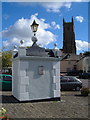
Ugborough conduit
"The Conduit in the Square was erected to celebrate Queen Victoria's Golden Jubilee in 1887 and served as the first piped water supply to the village. It contained a large cistern filled with water piped from a spring above the School. Water was conveyed to various sites in the village. The Conduit was in use until 1942". From http://www.ugborough.com/history/village_history.htm
Image: © Derek Harper
Taken: 29 Aug 2006
0.02 miles
7
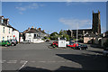
Ugborough: towards St Peter?s church
A view across the square. The church is said to stand on a prehistoric earthwork
Image: © Martin Bodman
Taken: 25 Jun 2008
0.02 miles
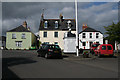
9
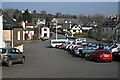
Ugborough: by the Ship Inn
At one end of The Square
Image: © Martin Bodman
Taken: 25 Jun 2008
0.02 miles
10
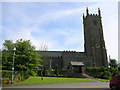
Ugborough Parish Church
This lovely Church at one time was known as the Cathedral of the South Hams. The earliest record of the church dates from 1121. The Norman nave and its supporting arcade were built before that date and it is possible there was an earlier church on this site. The Church and churchyard are entirely contained within a small prehistoric earthwork.
Image: © William Ward
Taken: 7 Jun 2005
0.03 miles