IMAGES TAKEN NEAR TO
Harford, IVYBRIDGE, PL21 0JE
Introduction
This page details the photographs taken nearby to PL21 0JE by members of the Geograph project.
The Geograph project started in 2005 with the aim of publishing, organising and preserving representative images for every square kilometre of Great Britain, Ireland and the Isle of Man.

There are currently over 7.5m images from over14,400 individuals and you can help contribute to the project by visiting https://www.geograph.org.uk
Image Map
Images are licensed for reuse under creativecommons.org/licenses/by-sa/2.0
Notes
- Clicking on the map will re-center to the selected point.
- The higher the marker number, the further away the image location is from the centre of the postcode.
Image Listing (37 Images Found)
Images are licensed for reuse under creativecommons.org/licenses/by-sa/2.0
Image
Details
Distance
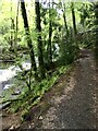
1
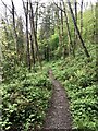
Permissive path
At the start of Erme Wood. On the East bank of the River Erme.
Image: © jeff collins
Taken: 15 May 2021
0.11 miles
2
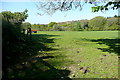
Field at Lukesland
Pasture leading to Erme Wood and the River Erme valley.
Image: © Graham Horn
Taken: 13 May 2012
0.11 miles
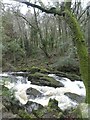
4
Rapids on River Erme
A view from below of the rapids shown in Image
Image: © Derek Harper
Taken: 13 Nov 2020
0.13 miles
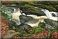
5
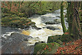
Rapids on River Erme
The river is running between Erme Wood on the far side and Longtimber Wood on this side.
Image: © Derek Harper
Taken: 13 Nov 2020
0.13 miles
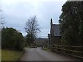
6

Lodge house at Lukesland
This is the entrance to Lukesland. It is a garden open to the public, but with very limited opening times.
Image: © Graham Horn
Taken: 13 May 2012
0.14 miles
7
Permissive path through Erme Wood
Following the East bank of the River Erme.
Image: © jeff collins
Taken: 15 May 2021
0.14 miles
8
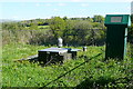
Water monitoring station at Lukesland
I don't know exactly what is going on here, but the site is operated by a water company and there is presumably machinery or telemetry inside that green, solar powered box.
Image: © Graham Horn
Taken: 13 May 2012
0.15 miles
10
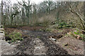
Disused pond by River Erme
The pond, whatever its original purpose, has been partly filled in.
Image: © Guy Wareham
Taken: 23 Mar 2016
0.15 miles