IMAGES TAKEN NEAR TO
Manor Gardens, YELVERTON, PL20 7UQ
Introduction
This page details the photographs taken nearby to Manor Gardens, PL20 7UQ by members of the Geograph project.
The Geograph project started in 2005 with the aim of publishing, organising and preserving representative images for every square kilometre of Great Britain, Ireland and the Isle of Man.

There are currently over 7.5m images from over14,400 individuals and you can help contribute to the project by visiting https://www.geograph.org.uk
Image Map
Images are licensed for reuse under creativecommons.org/licenses/by-sa/2.0
Notes
- Clicking on the map will re-center to the selected point.
- The higher the marker number, the further away the image location is from the centre of the postcode.
Image Listing (23 Images Found)
Images are licensed for reuse under creativecommons.org/licenses/by-sa/2.0
Image
Details
Distance
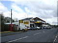
1
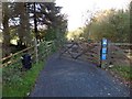
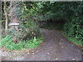
Drake's Trail leading to Tavistock
This is part of NCN27 (Devon Coast to Coast). This is the north end of the former Horrabridge railway station. From here the trail follows the track of the dismantled railway line
Image: © David Smith
Taken: 30 Oct 2012
0.04 miles
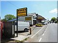
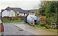
6
Old Toll House by the A386, Tavistock Road, Horrabridge
Toll House by the A386, in the parish of Horrabridge (West Devon District), Toll Booth, Tavistock Road, PL20.
Devon & Dartmoor HER.
HER Number: MDV72081 https://www.heritagegateway.org.uk/Gateway/Results_Single.aspx?uid=MDV72081&resourceID=104
Surveyed
Milestone Society National ID: DV.HOR02
Image: © Alan Rosevear
Taken: Unknown
0.14 miles
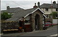
7
St John the Baptist's Church, Horrabridge, Devon
Architect: George Fellowes Prynne. Church consecrated in 1893.
Image: © Ruth Sharville
Taken: Unknown
0.14 miles
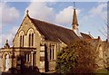
9
Site of former Horrabridge station
View southward, towards Plymouth: ex-GWR Plymouth - Tavistock - Lydford - Launceston branch, closed completely 31/12/62. Not much trace here - see also Image
Image: © Ben Brooksbank
Taken: 22 Apr 1995
0.15 miles