IMAGES TAKEN NEAR TO
Knighton Terrace, YELVERTON, PL20 7TS
Introduction
This page details the photographs taken nearby to Knighton Terrace, PL20 7TS by members of the Geograph project.
The Geograph project started in 2005 with the aim of publishing, organising and preserving representative images for every square kilometre of Great Britain, Ireland and the Isle of Man.

There are currently over 7.5m images from over14,400 individuals and you can help contribute to the project by visiting https://www.geograph.org.uk
Image Map (Loading...)


Getting Data...Please wait
Leaflet Map data © OpenStreetMap
Images are licensed for reuse under creativecommons.org/licenses/by-sa/2.0
Notes
- Clicking on the map will re-center to the selected point.
- The higher the marker number, the further away the image location is from the centre of the postcode.
Image Listing (24 Images Found)
Images are licensed for reuse under creativecommons.org/licenses/by-sa/2.0
Image
Details
Distance
2
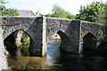
Horrabridge: the medieval bridge
An old crossing of the river Walkham, still used by present-day traffic
Image: © Martin Bodman
Taken: 12 May 2008
0.06 miles
3
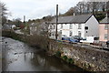
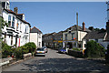
Whitchurch Road, Horrabridge
Buildings facing the River Walkham. On the immediate left is the pub shown in Image At the end of the road, beside the bridge, is the post office shown in Image
Image: © Derek Harper
Taken: 5 Mar 2012
0.07 miles
4
Horrabridge: Commercial Road
Looking towards the Post Office and the adjacent shop and off licence
Image: © Martin Bodman
Taken: 12 May 2008
0.08 miles
5
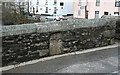
Old Wayside Cross by Graybridge Road, Horrabridge parish
Horrabridge Bridge cross, old head, shaft and base by the UC road, in parish of Horrabridge (West Devon District), Graybridge Road, on the old bridge over the River Walkham, in the western parapet of the bridge, set through the wall at the crown of the main arch.
Horrabridge Bridge is Grade I listed.
List Entry Number: 1105769 https://historicengland.org.uk/listing/the-list/list-entry/1105769
Surveyed
Milestone Society National ID: DVWD_HOR01
Image: © Alan Rosevear
Taken: 27 Feb 2010
0.09 miles
6
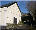
Old Methodist Chapel and School
Both these late 19th century buildings are now used for other purposes. The brightly painted chapel in the foreground has been converted to a workshop/warehouse and a private house. The school behind it, still complete with its bell on the roof, is an hotel.
Image: © Tony Atkin
Taken: 4 Dec 2005
0.10 miles
7
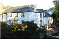
The Old Mill, Horrabridge
Former watermill on the River Walkham, now a private house.
Image: © M J Roscoe
Taken: 14 Sep 2016
0.10 miles
8
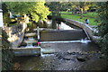
Weir, River Walkham, Horrabridge
On the left of the weir there is what appears to be a fish pass next to the former watermill. To the right of the river is Weir Park.
Image: © M J Roscoe
Taken: 14 Sep 2016
0.10 miles
9
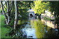
River Walkham, Horrabridge
Looking downstream in Weir Park towards the top of the weir, and beyond an arch of the 13th century stone bridge, on a early autumnal sunny evening.
Image: © M J Roscoe
Taken: 14 Sep 2016
0.10 miles