IMAGES TAKEN NEAR TO
Postbridge, YELVERTON, PL20 6TN
Introduction
This page details the photographs taken nearby to PL20 6TN by members of the Geograph project.
The Geograph project started in 2005 with the aim of publishing, organising and preserving representative images for every square kilometre of Great Britain, Ireland and the Isle of Man.

There are currently over 7.5m images from over14,400 individuals and you can help contribute to the project by visiting https://www.geograph.org.uk
Image Map
Images are licensed for reuse under creativecommons.org/licenses/by-sa/2.0
Notes
- Clicking on the map will re-center to the selected point.
- The higher the marker number, the further away the image location is from the centre of the postcode.
Image Listing (14 Images Found)
Images are licensed for reuse under creativecommons.org/licenses/by-sa/2.0
Image
Details
Distance
1
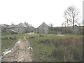
Pizwell from the East
A different view of Image
Image: © Stephen Craven
Taken: 18 Mar 2008
0.01 miles
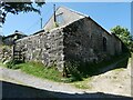
3
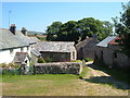
Dartmoor Forest: Pizwell
A Duchy of Cornwall hamlet with a complex of farm, longhouses and outbuildings. Pizwell first appeared in recorded history in 1260. In Dartmoor Forest parish
Image: © Martin Bodman
Taken: 6 Jul 2011
0.01 miles
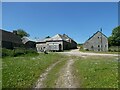
4
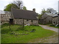
Longhouse at Pizwell
An old granite longhouse, for which there are plans to carry out restoration
Image: © David Smith
Taken: 26 May 2023
0.01 miles
5
Pizwell Farm
An isolated farmstead close to Postbridge.
Image: © Anthony Vosper
Taken: 13 May 2015
0.02 miles
6
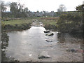
Ford at Pizwell
Pizwell Farm in thebackground
Image: © David Smith
Taken: 26 May 2023
0.04 miles
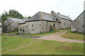
7
Pizwell
A remarkable collection of four longhouses plus shippons, the hamlet of Pizwell lies close to the Walla Brook
Image: © Derek Harper
Taken: 17 Jul 2005
0.05 miles
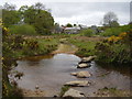
8
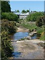
Stepping stones over the Walla Brook
The Explorer map shows a footbridge at this point but there was no evidence of it on the ground, only these stepping stones, which (even at the end of a dryish winter) were difficult to cross.
Image: © Stephen Craven
Taken: 18 Mar 2008
0.07 miles
9
Pizwell Farm and ford
Like many Dartmoor rivers and streams this could be hard work in bad weather.
Image: © Anthony Vosper
Taken: 13 May 2015
0.07 miles
10
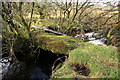
Footbridge near Pizwell
Marked on the OS 1:25000 map but little used, this bridge crosses Walla Brook just south of the ford. Accessing it is not easy.
Image: © Guy Wareham
Taken: 5 Feb 2010
0.08 miles