IMAGES TAKEN NEAR TO
Milton Combe, YELVERTON, PL20 6HQ
Introduction
This page details the photographs taken nearby to PL20 6HQ by members of the Geograph project.
The Geograph project started in 2005 with the aim of publishing, organising and preserving representative images for every square kilometre of Great Britain, Ireland and the Isle of Man.

There are currently over 7.5m images from over14,400 individuals and you can help contribute to the project by visiting https://www.geograph.org.uk
Image Map
Images are licensed for reuse under creativecommons.org/licenses/by-sa/2.0
Notes
- Clicking on the map will re-center to the selected point.
- The higher the marker number, the further away the image location is from the centre of the postcode.
Image Listing (19 Images Found)
Images are licensed for reuse under creativecommons.org/licenses/by-sa/2.0
Image
Details
Distance
1
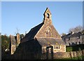
Milton Combe Church
The Church of the Holy Spirit was built in 1878.
Image: © Tony Atkin
Taken: 11 Dec 2005
0.00 miles
2
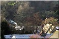
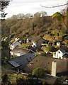
Roofs at Milton Combe
On the right is the roof and belfry of the Church of the Holy Spirit http://list.english-heritage.org.uk/resultsingle.aspx?uid=1326403&searchtype=mapsearch , overlooked, as far as I can tell, by Cherry & Pevsner. Even stranger is that the church is wrongly located on the more detailed OS maps, though the 1:25000 has it right. One feels that one has stepped into Nether Devon in this little village hemmed into a narrow valley.
Image: © Derek Harper
Taken: 11 Dec 2012
0.00 miles
3
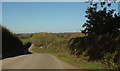
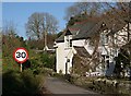
Lane above Milton Combe
Approaching the junction with Goosewell Lane, a footpath running down into the village.
Image: © Derek Harper
Taken: 20 Oct 2018
0.06 miles
4
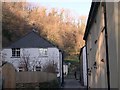
Milton Combe
The village of Milton Combe, as the name suggests, is situated in a narrow steep sided valley. The word "Combe" was added to the village name in 1890 at the request of the Post Office who wished to distinguish the village from other Miltons.
Image: © Tony Atkin
Taken: 11 Dec 2005
0.06 miles
5
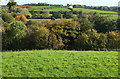
Field and wood near Milton Combe
Looking left from the gate Image] where Image] was taken. On the extreme left are Blowiscombe Cottages. Somewhere in between is the village of Milton Combe.
Image: © Derek Harper
Taken: 20 Oct 2018
0.06 miles
6
Milton Combe
Like Image], a view of the village from Alley Hill, but looking down the valley.
Image: © Derek Harper
Taken: 11 Dec 2012
0.06 miles
7
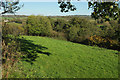
View over Milton Combe
Looking more to the left than Image], with the village hidden by woodland. On the hill opposite is Bickham.
Image: © Derek Harper
Taken: 20 Oct 2018
0.08 miles
9
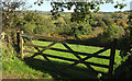
Gate above Milton Combe
Image: © Derek Harper
Taken: 20 Oct 2018
0.09 miles
10
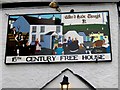
Pub sign - Milton Combe
The "Who'd Have Thought It" pub sign depicts a merry village scene.
Image: © Sarah Smith
Taken: 18 May 2011
0.11 miles