IMAGES TAKEN NEAR TO
Devonia Court, PL20 6FN
Introduction
This page details the photographs taken nearby to Devonia Court, PL20 6FN by members of the Geograph project.
The Geograph project started in 2005 with the aim of publishing, organising and preserving representative images for every square kilometre of Great Britain, Ireland and the Isle of Man.

There are currently over 7.5m images from over14,400 individuals and you can help contribute to the project by visiting https://www.geograph.org.uk
Image Map
Images are licensed for reuse under creativecommons.org/licenses/by-sa/2.0
Notes
- Clicking on the map will re-center to the selected point.
- The higher the marker number, the further away the image location is from the centre of the postcode.
Image Listing (81 Images Found)
Images are licensed for reuse under creativecommons.org/licenses/by-sa/2.0
Image
Details
Distance
2
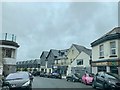
Leg O' Mutton Corner
This is a strange place, it looks like a village centre having shops and a large public house/hotel but it is in an isolated position separated from the body of Yelverton by the main road to Tavistock and facing the open heathland of Roborough Down (behind the photographer). History probably has a lot to do with it. Construction of the airfield for RAF Harrowbeer in WWII forced the main road to be moved away from this corner. Nowadays the area probably survives on the fact that it is easy to park a car here.
Image: © Tony Atkin
Taken: 13 Apr 2008
0.01 miles
3
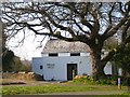
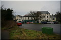
Drake Vets - Leg of Mutton
Just off the carpark is a veterinary surgery looking very picturesque situated behind the oak tree.
Image: © Sarah Smith
Taken: 23 Mar 2011
0.02 miles
4
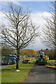
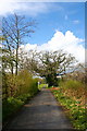
Making a new Cycle Path
A new cycle path is being constructed on the edge of the common land between Horrabridge and Yelverton. Photographed here near the car park at Leg O' Mutton.
Image: © Tony Atkin
Taken: 13 Apr 2008
0.02 miles
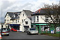
6
Shops at Yelverton
Close to here is the start of Drakes Trail to Tavistock.
Image: © jeff collins
Taken: 8 Jan 2014
0.03 miles
7
Footpath to Leg O' Mutton
The footpath between Roborough Roundabout and the area known as Leg O' Mutton after the name of the pub.
Image: © Tony Atkin
Taken: 13 Apr 2008
0.03 miles
8
Board describing RAF Harrowbeer, a WW2 airfield
A detailed picture is at Image
Image: © David Smith
Taken: 11 Sep 2021
0.04 miles
9
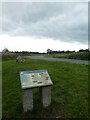
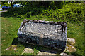
Memorial on Roborough Down
Commemorating the World War II air station RAF Harrowbear.
Image: © Ron Strutt
Taken: 4 Sep 2003
0.04 miles
10
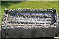
RAF Harrowbeer: a tour of a WW2 airfield - Station Memorial (25)
The tour ends here at the memorial to all the personnel of many different nationalities who served at Harrowbeer 1941 - 1949. The inscription reads:
"RAF Harrowbeer operational 1941 - 1949. From this station flew pilots of many Commonwealth and Allied countries, including Britain, Canada, Czechoslavakia, France, Poland, Rhodesia and the United States of America. With the support of their ground crew and airfield defence units. This stone is in memory of all who served here and especially of those who gave their lives. Many local residents helped build and maintain this airfield. Unveiled by the first Station Commander. Group Captain the Honourable E. F. Ward on 15th August 1981, the fortieth anniversary of the opening of this station."
START of TOUR: Image
Image: © Mike Searle
Taken: 5 May 2019
0.04 miles