IMAGES TAKEN NEAR TO
Peter Tavy, TAVISTOCK, PL19 9NS
Introduction
This page details the photographs taken nearby to PL19 9NS by members of the Geograph project.
The Geograph project started in 2005 with the aim of publishing, organising and preserving representative images for every square kilometre of Great Britain, Ireland and the Isle of Man.

There are currently over 7.5m images from over14,400 individuals and you can help contribute to the project by visiting https://www.geograph.org.uk
Image Map
Images are licensed for reuse under creativecommons.org/licenses/by-sa/2.0
Notes
- Clicking on the map will re-center to the selected point.
- The higher the marker number, the further away the image location is from the centre of the postcode.
Image Listing (51 Images Found)
Images are licensed for reuse under creativecommons.org/licenses/by-sa/2.0
Image
Details
Distance
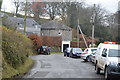
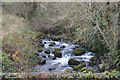
2
Demolition site, Peter Tavy
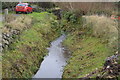
The site of a garage which was demolished http://3.bp.blogspot.com/-YcVQ5v12PSM/TcxANrUxdbI/AAAAAAAAAOE/o8-U37nXrog/s1600/P1070983.JPG in May 2011. Planning permission for a dwelling was recently refused. Unfortunate that this site is one of the main foci of the village. As http://www.dartmoor-npa.gov.uk/__data/assets/pdf_file/0019/252028/20120706-DM-Reports.pdf states, "It is a sensitive open site whose character was much altered by the construction of the garage ... the preferred outcome ... would be for reversion to the situation prior to construction of the recent garage and forecourt use and no further development in this location."
On the right is the Colly Brook.
Image: © Derek Harper
Taken: 11 Dec 2012
0.06 miles
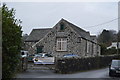
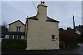
3
Cottages at Peter Tavy
Overlooking the Mill Leat as it runs through the village.
Image: © Derek Harper
Taken: 11 Dec 2012
0.06 miles
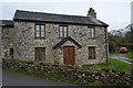
4
Midhurst Cottage
Grade II listed. https://www.britishlistedbuildings.co.uk/101171173-midhurst-cottage-and-post-office-peter-tavy
Image: © N Chadwick
Taken: 2 Dec 2017
0.07 miles
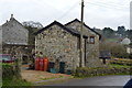
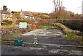
9
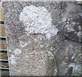
Ordnance Survey Cut Mark
This OS cut mark can be found on the garden gatepost on the west side of the road. It marks a point 162.434m above mean sea level.
Image: © Adrian Dust
Taken: 27 Apr 2016
0.08 miles