IMAGES TAKEN NEAR TO
Whitchurch Road, TAVISTOCK, PL19 9EY
Introduction
This page details the photographs taken nearby to Whitchurch Road, PL19 9EY by members of the Geograph project.
The Geograph project started in 2005 with the aim of publishing, organising and preserving representative images for every square kilometre of Great Britain, Ireland and the Isle of Man.

There are currently over 7.5m images from over14,400 individuals and you can help contribute to the project by visiting https://www.geograph.org.uk
Image Map
Images are licensed for reuse under creativecommons.org/licenses/by-sa/2.0
Notes
- Clicking on the map will re-center to the selected point.
- The higher the marker number, the further away the image location is from the centre of the postcode.
Image Listing (245 Images Found)
Images are licensed for reuse under creativecommons.org/licenses/by-sa/2.0
Image
Details
Distance
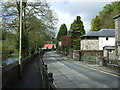
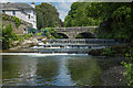
3
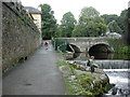
River Tavy at Tavistock Bridge
A fine June afternoon.
Image: © Jonathan Billinger
Taken: 14 Jun 2011
0.03 miles
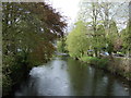
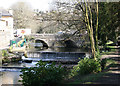
4
River Tavy, Tavistock
In the distance is Abbey Bridge, built in 1763 and widened in 1860, when the 'new' railway station was opened just up the road and the bridge had a greatly increased traffic flow.
Image: © Richard Rogerson
Taken: 9 Jun 2021
0.04 miles
5
Weir on the River Tavy
The weir is the intake point for the Tavistock Canal which feeds the Morwellham hydro power station.
Image: © Guy Wareham
Taken: 3 Jun 2016
0.04 miles
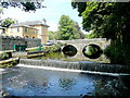
6
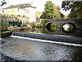
Tavistock: River Tavy and Abbey Bridge
Quoting from the Devon County Council's plaque on Abbey Bridge:-
"A mediaeval bridge here served Tavistock Abbey.
It was replaced in 1763 to accommodate the new
turnpike road system. This bridge was widened in 1860
to carry increased traffic following the opening
of the Great Western Railway station nearby."
Today it carries the A386 road to and from Okehampton into the town centre.
On the left is the intake from the River Tavy that feeds the Tavistock Canal which has served Morwellham hydro power station since 1934. In 2008 a new automatic screening mechanism was installed (the green and grey shovel-like structure) that will prevent salmon smolts from entering the canal and becoming trapped, instead allowing them to swim down the Tavy to the sea.
Image: © Nigel Cox
Taken: 17 Oct 2008
0.04 miles
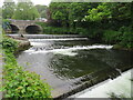
7
River Tavy and Weir
More like Summer the March today
Image: © roger geach
Taken: 29 Mar 2012
0.04 miles
8
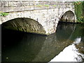
Tavistock, Abbey Bridge
River Tavy bridge, close to the Abbey wall and weir.
Image: © Ian James Cox
Taken: 30 Sep 2009
0.04 miles
9
Tavistock, fish screen
Fish screening device, to prevent salmon smolts entering power station water supply.
Image: © Mike Faherty
Taken: 27 Jul 2010
0.04 miles
10
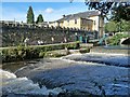
Weir on the River Tavy, Tavistock
The river is running high following several spells of heavy rain.
Image: © Robin Drayton
Taken: 6 Oct 2012
0.04 miles