IMAGES TAKEN NEAR TO
Lamerton, TAVISTOCK, PL19 8RW
Introduction
This page details the photographs taken nearby to PL19 8RW by members of the Geograph project.
The Geograph project started in 2005 with the aim of publishing, organising and preserving representative images for every square kilometre of Great Britain, Ireland and the Isle of Man.

There are currently over 7.5m images from over14,400 individuals and you can help contribute to the project by visiting https://www.geograph.org.uk
Image Map
Images are licensed for reuse under creativecommons.org/licenses/by-sa/2.0
Notes
- Clicking on the map will re-center to the selected point.
- The higher the marker number, the further away the image location is from the centre of the postcode.
Image Listing (49 Images Found)
Images are licensed for reuse under creativecommons.org/licenses/by-sa/2.0
Image
Details
Distance
2
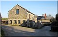
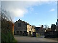
Court Barton, Lamerton
A slightly closer look than Image The lane to Chaddlehanger bends sharply left here; Lamerton Footpath 25 leaves to the right, taking you to the church.
Image: © Derek Harper
Taken: 8 Mar 2014
0.02 miles
3
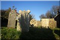
Gravestones, Lamerton
Several of the monuments in the churchyard are listed, but I don't think these are among them.
Image: © Derek Harper
Taken: 8 Mar 2014
0.04 miles
4
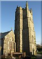
Church of St Peter, Lamerton
The grade II* listed church is thoroughly described at http://list.english-heritage.org.uk/resultsingle.aspx?uid=1171163&searchtype=mapsearch . The tower's diagonal buttresses and the stair-tower can be seen here. Lamerton Footpath 25
runs through the churchyard.
Image: © Derek Harper
Taken: 8 Mar 2014
0.04 miles
5
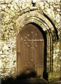
Door, St Peter's church, Lamerton
The west door at the foot of the tower of Image "West door with 2-centred arch chamfered and hollow-chamfered surround, hood-mould and relieving arch, C19 door with strap hinges, date 1806" http://list.english-heritage.org.uk/resultsingle.aspx?uid=1171163&searchtype=mapsearch .
Image: © Derek Harper
Taken: 8 Mar 2014
0.04 miles
6
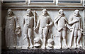
St Peter's church, Lamerton - the Tremayne brothers monument (detail)
Image: © Mike Searle
Taken: 24 Jun 2013
0.04 miles
7
St Peter's church, Lamerton - the Tremayne brothers monument
Monument to five brothers of the Tremayne family. The first figure depicts Roger Tremayne in doctor's robes, holding a mortar board. Next are the twins Richard and John, both are in armour; they were killed separately in battle, one died avenging his twin's death. The next two are Edmund, and Digory, both wearing cloaks.
Image: © Mike Searle
Taken: 24 Jun 2013
0.04 miles
8
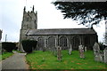
Lamerton Parish Church
Partly destroyed by fire in 1877 the tower is the only original part left.
Image: © jeff collins
Taken: 27 Nov 2013
0.04 miles
9
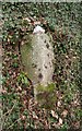
Old Guide Stone by Y-junction to Great Haye, Lamerton
Flat top granite guide stone by the UC road, in parish of Lamerton (West Devon District), at Y-junction to Great Haye, North of the church, high in the hedge bank.
Surveyed
Milestone Society National ID: DV_XLAME1
Image: © Alan Rosevear
Taken: 8 Mar 2012
0.05 miles
10
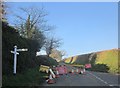
Road closed, Lamerton
The lane to Brent Tor is closed except for access, so traffic is diverted along the Chaddlehanger lane instead.
Image: © Derek Harper
Taken: 8 Mar 2014
0.05 miles