IMAGES TAKEN NEAR TO
Greenhill, TAVISTOCK, PL19 8QP
Introduction
This page details the photographs taken nearby to Greenhill, PL19 8QP by members of the Geograph project.
The Geograph project started in 2005 with the aim of publishing, organising and preserving representative images for every square kilometre of Great Britain, Ireland and the Isle of Man.

There are currently over 7.5m images from over14,400 individuals and you can help contribute to the project by visiting https://www.geograph.org.uk
Image Map
Images are licensed for reuse under creativecommons.org/licenses/by-sa/2.0
Notes
- Clicking on the map will re-center to the selected point.
- The higher the marker number, the further away the image location is from the centre of the postcode.
Image Listing (28 Images Found)
Images are licensed for reuse under creativecommons.org/licenses/by-sa/2.0
Image
Details
Distance
1
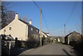
Green Hill, Lamerton
The lane connecting Lamerton Green to Lamerton itself. One of the buildings on the left is listed http://list.english-heritage.org.uk/resultsingle.aspx?uid=1326230&searchtype=mapsearch but it's difficult to work out which. The structure on the right backs onto the village's sports and community centre car park.
Image: © Derek Harper
Taken: 8 Mar 2014
0.02 miles
2
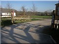
Entrance, Lamerton Sports & Community Centre
The vehicle entrance to the centre and its field, from Green Hill.
Image: © Derek Harper
Taken: 8 Mar 2014
0.03 miles
3
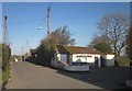
Car park, Blacksmiths Arms, Lamerton Green
Were these once the pub's loos? The car park is off Green Hill, the lane that links Lamerton Green to the village itself.
Image: © Derek Harper
Taken: 8 Mar 2014
0.04 miles
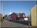
4
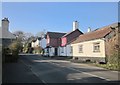
Blacksmiths Arms, Lamerton Green
Formerly the Fortescue Arms, according to http://www.bbc.co.uk/history/domesday/dblock/GB-244000-75000/page/2 , and with a jettied upper storey.
Image: © Derek Harper
Taken: 8 Mar 2014
0.05 miles
5
Blacksmiths Arms, Lamerton Green
A similar view to Image of the pub also shown in Image The road ahead, to the left of the pub, leads into Lamerton.
Image: © Derek Harper
Taken: 8 Mar 2014
0.05 miles
6
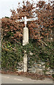
Old Direction Sign - Signpost by Lamerton Green, Lamerton parish
Pyramid finial - 3 arms; Stone post with metal mount by the former B3362, in parish of Lamerton (West Devon District), Green Hill and The Farriers junction, opposite the Blacksmith's Arms PH, in stone wall.
Grade II listed.
List Entry Number: 1105748 https://historicengland.org.uk/listing/the-list/list-entry/1105748
Surveyed
Milestone Society National ID: DV_SX4476
Image: © Alan Rosevear
Taken: 8 Mar 2012
0.05 miles
7
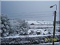
Sunny Devon
It is not often that it snows in Devon, but this lot fell in about 2 hours. Looking out of the bedroom window at Winslade Farm and general fields.
Image: © yorkiemalone
Taken: 25 Nov 2005
0.07 miles
8
Blacksmith Arms From my garden
This is the Blacksmiths, taken from my garden. The first two houses on the right are very old, the next two have been built where an agricultural repair garage , called Wickets, was.
Image: © yorkiemalone
Taken: 18 Feb 2007
0.07 miles
9
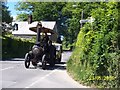
Traction Engine passing through Lamerton
I had my back to the Blacksmiths Arms. Note the finger post; Chipshop is an area south-west of Lamerton.
Image: © yorkiemalone
Taken: 23 May 2007
0.08 miles
10
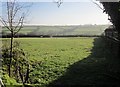
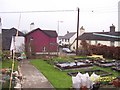
Field, Lamerton Green
Between the village hall and the hamlet, and seen from the stile where Lamerton Footpath 2 sets out across it.
Image: © Derek Harper
Taken: 8 Mar 2014
0.10 miles