IMAGES TAKEN NEAR TO
Howard Close, TAVISTOCK, PL19 8ND
Introduction
This page details the photographs taken nearby to Howard Close, PL19 8ND by members of the Geograph project.
The Geograph project started in 2005 with the aim of publishing, organising and preserving representative images for every square kilometre of Great Britain, Ireland and the Isle of Man.

There are currently over 7.5m images from over14,400 individuals and you can help contribute to the project by visiting https://www.geograph.org.uk
Image Map
Images are licensed for reuse under creativecommons.org/licenses/by-sa/2.0
Notes
- Clicking on the map will re-center to the selected point.
- The higher the marker number, the further away the image location is from the centre of the postcode.
Image Listing (9 Images Found)
Images are licensed for reuse under creativecommons.org/licenses/by-sa/2.0
Image
Details
Distance
1
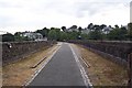
Tavistock Viaduct
Tavistock Viaduct was immediately south-west of the site of the Southern Railway station at Tavistock (behind the photographer). It is now used by the Granite Way cycle route.
Image: © Ron Strutt
Taken: 3 Sep 2003
0.06 miles
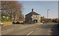
2
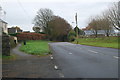
New Launceston Road, Tavistock
Heading into Tavistock on the outskirts of the market town.
Image: © jeff collins
Taken: 27 Nov 2013
0.08 miles
3

Old Launceston Road, Tavistock
Further up the hill shown in Image], with Courtlands Road turning off to the right, and St Maryhaye on the left.
Image: © Derek Harper
Taken: 8 Mar 2014
0.10 miles
4
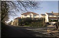
Courtlands Close, Tavistock
The main road here is the Old Launceston Road, long superseded as the principal route to that town.
Image: © Derek Harper
Taken: 8 Mar 2014
0.12 miles
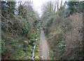
5
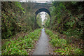
Viaduct Walk
A shared use path along the dismantled LSWR line from Tavistock North to Plymouth.
Image: © Guy Wareham
Taken: 25 Dec 2016
0.13 miles
6
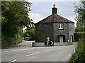
Old Toll House
This old turnpike toll house sits on the junction of Old Launceston Road and the main road, appropriately called New Launceston Road.
Image: © Tony Atkin
Taken: 25 Jun 2006
0.13 miles
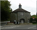
7
Pixon Cottage, Tavistock
Also shown in Image, this octagonal toll-house is described at http://list.english-heritage.org.uk/resultsingle.aspx?uid=1309306&searchtype=mapsearch .
Image: © Derek Harper
Taken: 8 Mar 2014
0.19 miles
8
Old Toll House by the B3362, Old Launceston Road, Pixon
Pixon Toll Cottage by the B3362, in the parish of Tavistock (West Devon District), The Round House, Old Launceston Road, Pixon, PL19 8NG.
Grade II listed.
List Entry Number: 1309306 https://historicengland.org.uk/listing/the-list/list-entry/1309306
Surveyed
Milestone Society National ID: DV.TAV02
Image: © Alan Rosevear
Taken: Unknown
0.19 miles
9
Once the LSWR Railway from Exeter to Plymouth
This line shut in May 1968 and part of the trackbed is now a cycleway. Looking towards Bere Alston. This was the former London and South Western Route to Plymouth latterly run by the Southern Region of BR until the Western Region took over and shut the line.A town the size of Tavistock should never have lost its railway. Look at the cars on the Plymouth to Tavistock road.
Image: © roger geach
Taken: 5 Apr 2010
0.20 miles