IMAGES TAKEN NEAR TO
Uplands, TAVISTOCK, PL19 8ES
Introduction
This page details the photographs taken nearby to Uplands, PL19 8ES by members of the Geograph project.
The Geograph project started in 2005 with the aim of publishing, organising and preserving representative images for every square kilometre of Great Britain, Ireland and the Isle of Man.

There are currently over 7.5m images from over14,400 individuals and you can help contribute to the project by visiting https://www.geograph.org.uk
Image Map (Loading...)


Getting Data...Please wait
Leaflet Map data © OpenStreetMap
Images are licensed for reuse under creativecommons.org/licenses/by-sa/2.0
Notes
- Clicking on the map will re-center to the selected point.
- The higher the marker number, the further away the image location is from the centre of the postcode.
Image Listing (7 Images Found)
Images are licensed for reuse under creativecommons.org/licenses/by-sa/2.0
Image
Details
Distance
3
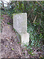
Old Guide Stone by the A390, Callington Road, Tavistock
Tavistock Guidestone by the A390, in parish of Tavistock (West Devon District), Callington Road, by Martin's Cottage, 60m West of town sign, in hedge of lay-by, West of field gate.
Devon & Dartmoor HER.
HER Number: MDV103786 https://historicengland.org.uk/listing/the-list/map-search?clearresults=True/#?search=SU1557854738
Surveyed
Milestone Society National ID: DV_XTAV01
Image: © Alan Rosevear
Taken: 3 Mar 2013
0.23 miles
4
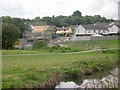
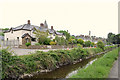
Housebuilding
New housing on the edge of Tavistock. The water in the foreground is the Tavistock Canal.
Image: © Tony Atkin
Taken: 29 Aug 2005
0.24 miles
5
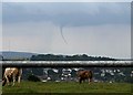
Tornado
This twister was seen from the western edge of Tavistock. The funnel cloud itself was somewhere over the western edge of Dartmoor between Princetown and Yelverton. The mast on the left side of the picture is on North Hessary Tor. The weather conditions at the time were hot and humid with cloud and showers building up over the land and a light breeze. There were no reports of damage. As photographed here it is not actually a tornado, just a funnel cloud, as it is not touching the ground although a photograph of this storm printed in a local newspaper the following day did appear to show this happening.
Image: © Tony Atkin
Taken: 25 Jun 2006
0.24 miles
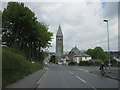
6
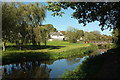
Green space by the Tavistock Canal
With the bridge shown in Image] on the right, and houses on Trinity Way.
Image: © Derek Harper
Taken: 20 Oct 2018
0.25 miles