IMAGES TAKEN NEAR TO
Edgcumbe Drive, TAVISTOCK, PL19 0ET
Introduction
This page details the photographs taken nearby to Edgcumbe Drive, PL19 0ET by members of the Geograph project.
The Geograph project started in 2005 with the aim of publishing, organising and preserving representative images for every square kilometre of Great Britain, Ireland and the Isle of Man.

There are currently over 7.5m images from over14,400 individuals and you can help contribute to the project by visiting https://www.geograph.org.uk
Image Map
Images are licensed for reuse under creativecommons.org/licenses/by-sa/2.0
Notes
- Clicking on the map will re-center to the selected point.
- The higher the marker number, the further away the image location is from the centre of the postcode.
Image Listing (23 Images Found)
Images are licensed for reuse under creativecommons.org/licenses/by-sa/2.0
Image
Details
Distance
1
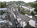
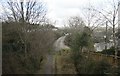
Tavistock roofscape (1)
Viewed from Tavistock Viaduct, the photograph shows Bannawell Street on the left, Lakeside on the right, and houses on Drake Road on the upper right.
Image: © Nigel Cox
Taken: 6 Oct 2008
0.13 miles
2
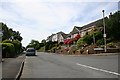
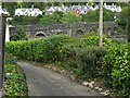
Redmoor Close, Tavistock
A modern suburban development on the northern edge of Tavistock. It's a short walk from the town centre to here but very steep uphill.
Image: © Tony Atkin
Taken: 4 Jun 2006
0.15 miles
3
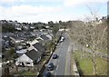
View from above
The view from the former railway viaduct looking away from Tavistock. The road on the right led into the former station goods yard and upside platforms.
Image: © roger geach
Taken: 4 Apr 2010
0.15 miles
4
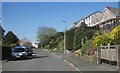
Redmoor Close, Tavistock
Taken a little further up the road shown in Image
Image: © Derek Harper
Taken: 14 Apr 2015
0.16 miles
5
LSWR Exeter - Plymouth looking towards Tavistock North
Now getting overgrown , once you would have had a great view of a train departing from Tavistock North to Bere Alston. The line shut in May 1968 and now is a footpath / cycle way across the viaduct. Part of the trackbed the other side of the viaduct at the former Tavistock North station has been built over. This view is looking towards the old station and the Exeter direction. The track was lifted in late 1969 early winter 1970.
Image: © roger geach
Taken: 5 Apr 2010
0.19 miles
6
Former railway viaduct, Tavistock
Now a public path. There are good views to be had from the viaduct over the town below.
Image: © Chris Allen
Taken: 21 Sep 2021
0.20 miles
7
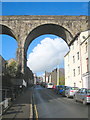
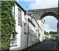
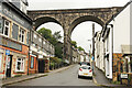
Viaduct on the old LSWR railway
Crossing Bannawell Street. The railway was axed as part of the Beeching cuts and closed in 1968.
Image: © Rod Allday
Taken: 17 Nov 2010
0.20 miles
8
Taylor Square
The viaduct of the former LSWR route from Plymouth via Okehampton to Exeter and on to London (Waterloo) crosses high above the town. These old houses are in Taylor Square. The viaduct is now a permissive path.
Image: © Graham Horn
Taken: 31 May 2011
0.20 miles
9

Old Launceston Road, Tavistock
Further up the hill shown in Image], with Courtlands Road turning off to the right, and St Maryhaye on the left.
Image: © Derek Harper
Taken: 8 Mar 2014
0.20 miles
10
King Street
View up King Street to the former railway viaduct now route 270 of the National Cycle Network
Image: © Richard Croft
Taken: 8 Sep 2022
0.20 miles