IMAGES TAKEN NEAR TO
Sims Terrace, GUNNISLAKE, PL18 9DQ
Introduction
This page details the photographs taken nearby to Sims Terrace, PL18 9DQ by members of the Geograph project.
The Geograph project started in 2005 with the aim of publishing, organising and preserving representative images for every square kilometre of Great Britain, Ireland and the Isle of Man.

There are currently over 7.5m images from over14,400 individuals and you can help contribute to the project by visiting https://www.geograph.org.uk
Image Map
Images are licensed for reuse under creativecommons.org/licenses/by-sa/2.0
Notes
- Clicking on the map will re-center to the selected point.
- The higher the marker number, the further away the image location is from the centre of the postcode.
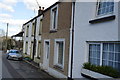
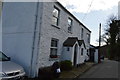
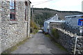
Image Listing (73 Images Found)
Images are licensed for reuse under creativecommons.org/licenses/by-sa/2.0
Image
Details
Distance
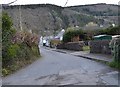
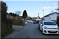
1
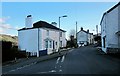
Junction, Gunnislake
Under Road (left) meets Calstock Road. The village is in the deep Tamar valley, and the sunshine has departed from this side; you can see it on the west-facing slopes.
Image: © Derek Harper
Taken: 4 Mar 2015
0.03 miles
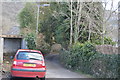
5
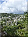
Gunnislake from Chimney Rock
Looking across the River Tamar from the prominent rock outcrop in Hatch Wood
Image: © David Smith
Taken: 28 Aug 2015
0.05 miles