IMAGES TAKEN NEAR TO
St. Anns Chapel, GUNNISLAKE, PL18 9BG
Introduction
This page details the photographs taken nearby to PL18 9BG by members of the Geograph project.
The Geograph project started in 2005 with the aim of publishing, organising and preserving representative images for every square kilometre of Great Britain, Ireland and the Isle of Man.

There are currently over 7.5m images from over14,400 individuals and you can help contribute to the project by visiting https://www.geograph.org.uk
Image Map
Images are licensed for reuse under creativecommons.org/licenses/by-sa/2.0
Notes
- Clicking on the map will re-center to the selected point.
- The higher the marker number, the further away the image location is from the centre of the postcode.
Image Listing (8 Images Found)
Images are licensed for reuse under creativecommons.org/licenses/by-sa/2.0
Image
Details
Distance
1
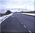
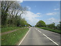
The A390 at Sevenstones
View westwards as the road begins its descent and sweep left to Callington. Ahead is a snow-covered Kit Hill.
http://www.cornishlight.co.uk/kit-hill.htm
Image: © Trevor Rickard
Taken: Unknown
0.09 miles
2
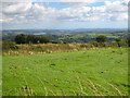
Pasture at Rising Sun Farm
Looking down the Tamar Valley towards Plymouth and the sea in the far distance.
Image: © Rod Allday
Taken: 4 Aug 2010
0.13 miles
3
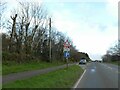
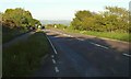
Lay-by by A390 to west of Mount Pleasant
There is advance warning of cycles crossing because the cycle track is on the left of the road and cyclists will cross to a track on the right. Pedestrians must also cross, but there is no advance warning, possibly because there is very little pedestrian traffic on the path on the left
Image: © David Smith
Taken: 3 Dec 2022
0.14 miles
5
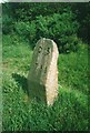
Old Milestone by the A390, West of St Ann's Chapel
Carved stone post by the A390, in parish of CALSTOCK (CARADON District), Hingston Down, West of St Ann's Chapel, on ridge, on North side of road. Callington CT tombstone, erected by the Callington turnpike trust in the 19th century.
Inscription reads:-
C.3
T.6½
Grade II Listed. List Entry Number: 1392536
https://historicengland.org.uk/listing/the-list/list-entry/1392536
Milestone Society National ID: CW_CLTV03.
Image: © Ian Thompson
Taken: 13 Aug 2012
0.22 miles
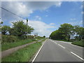
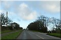
6
A390 on Mount Pleasant
Seen from the lay-by visible in Image Ahead on the right is the right turn into Lower Mount Pleasant Farm.
Image: © Derek Harper
Taken: 14 May 2014
0.22 miles
7
A390 junction with road south to Harrowbarrow
Image: © David Smith
Taken: 3 Dec 2022
0.23 miles