IMAGES TAKEN NEAR TO
Stoke Climsland, CALLINGTON, PL17 8NA
Introduction
This page details the photographs taken nearby to PL17 8NA by members of the Geograph project.
The Geograph project started in 2005 with the aim of publishing, organising and preserving representative images for every square kilometre of Great Britain, Ireland and the Isle of Man.

There are currently over 7.5m images from over14,400 individuals and you can help contribute to the project by visiting https://www.geograph.org.uk
Image Map
Images are licensed for reuse under creativecommons.org/licenses/by-sa/2.0
Notes
- Clicking on the map will re-center to the selected point.
- The higher the marker number, the further away the image location is from the centre of the postcode.
Image Listing (4 Images Found)
Images are licensed for reuse under creativecommons.org/licenses/by-sa/2.0
Image
Details
Distance
1
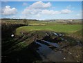
Field near Holwell House
Looking to the left from the same spot as Image], with overlap. Away on the right is the Tamar valley.
Image: © Derek Harper
Taken: 4 Mar 2015
0.11 miles
2
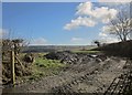
Field near Holwell House
This looks a bit like a pile of coal, but it must just be the fact that we're looking into the sun.
Image: © Derek Harper
Taken: 4 Mar 2015
0.14 miles
3
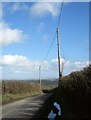
Lane to Horsebridge
The lane from Stoke Climsland begins a steady descent of 100 metres in two kilometres into the Tamar valley.
Image: © Derek Harper
Taken: 4 Mar 2015
0.15 miles
4
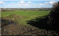
Field near Holwell House
Looking along the line of footpath 553 13/1 as it leaves the lane shown in Image] and heads diagonally across the field towards South Alston. A good view from here across to Dartmoor, with the church tower of Sydenham Damerel visible at larger magnifications in the centre.
Image: © Derek Harper
Taken: 4 Mar 2015
0.17 miles