IMAGES TAKEN NEAR TO
Parsons Green, CALLINGTON, PL17 8EY
Introduction
This page details the photographs taken nearby to Parsons Green, PL17 8EY by members of the Geograph project.
The Geograph project started in 2005 with the aim of publishing, organising and preserving representative images for every square kilometre of Great Britain, Ireland and the Isle of Man.

There are currently over 7.5m images from over14,400 individuals and you can help contribute to the project by visiting https://www.geograph.org.uk
Image Map (Loading...)


Getting Data...Please wait
Leaflet Map data © OpenStreetMap
Images are licensed for reuse under creativecommons.org/licenses/by-sa/2.0
Notes
- Clicking on the map will re-center to the selected point.
- The higher the marker number, the further away the image location is from the centre of the postcode.
Image Listing (23 Images Found)
Images are licensed for reuse under creativecommons.org/licenses/by-sa/2.0
Image
Details
Distance
1
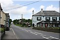
Along the road at Kelly Bray
Looking north out of the village, the pub on the right is called The Swingletree.
Image: © Tony Atkin
Taken: 19 May 2007
0.06 miles
2
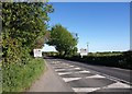
Approaching Kelly Bray
The speed restriction signs and village name, here about 100 metres before the built-up area begins along the A388. Seen from the lay-by shown in Image
Image: © Derek Harper
Taken: 14 May 2014
0.11 miles
3
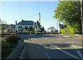
Junction, Kelly Bray
The A388 forks left here on its way out of the village. Ahead is Stoke Road, to Stoke Climsland. In the angel between them is The Swingle Tree pub, also shown in Image
Image: © Derek Harper
Taken: 14 May 2014
0.13 miles
4
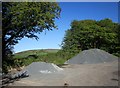
Lay-by on the A388
Northwest of Kelly Bray, with a view over the gravel heaps to Kit Kill.
Image: © Derek Harper
Taken: 14 May 2014
0.13 miles
5

Notice in Kelly Bray
"Piglets and weaners for sale"; a notice beside the A388 in the centre of the village.
Image: © Derek Harper
Taken: 14 May 2014
0.18 miles
6
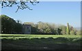
Holmbush Mine
A view across a field from the A388. On the left are the remains of the engine house https://historicengland.org.uk/listing/the-list/list-entry/1220764 ; to the right is a chimney https://historicengland.org.uk/listing/the-list/list-entry/1220760 . A further chimney is virtually hidden in shadows on the left https://historicengland.org.uk/listing/the-list/list-entry/1290834 . "The Hitchen's Shaft complex at the Holmbush Mine survives well as a very good example of the range of features and structures grouped to serve the needs of a mid- to later 19th century shaft head in a non-ferrous metals mine" https://historicengland.org.uk/listing/the-list/list-entry/1020435 , which gives a detailed account.
Image: © Derek Harper
Taken: 14 May 2014
0.18 miles
7
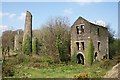
Holmbush Mine
This is the remains of the buildings surrounding part of Holmbush Mine. Conservation work was carried out in 2007 and it is reasonably safe to walk around these buildings provided you are careful. There are the remains of three engine houses along with the boiler house chimney which is still just about standing. I have no specific information about the engine houses but the one in the foreground has a very wide arched entrance and if you walk inside you can still see the bolt holes which were used to anchor the engine to the ground. This building must have housed very large engine, possibly 100 inch cylinder. Such large engine were almost always used to pump water from the mine workings.
Image: © Tony Atkin
Taken: 20 Apr 2009
0.18 miles
8
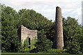
Disused mine buildings near Kelly Bray
A more recent view of the buildings at the right hand side of Image, now more overgrown and with a reduced chimney.
Image: © Pierre Terre
Taken: 7 Aug 2006
0.18 miles
9
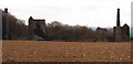
Disused mine buildings, near Kelly Bray
View of Holmbush Mine, north of Kelly Bray 200m east off the A388. Photographed in 1979
Image: © Crispin Purdye
Taken: Unknown
0.18 miles
10
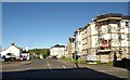
Station Road, Kelly Bray
Seen across the T junction where Station Road, the B3257, meets the A388. On the right are flats.
Image: © Derek Harper
Taken: 14 May 2014
0.18 miles