IMAGES TAKEN NEAR TO
CALLINGTON, PL17 7JU
Introduction
This page details the photographs taken nearby to PL17 7JU by members of the Geograph project.
The Geograph project started in 2005 with the aim of publishing, organising and preserving representative images for every square kilometre of Great Britain, Ireland and the Isle of Man.

There are currently over 7.5m images from over14,400 individuals and you can help contribute to the project by visiting https://www.geograph.org.uk
Image Map
Images are licensed for reuse under creativecommons.org/licenses/by-sa/2.0
Notes
- Clicking on the map will re-center to the selected point.
- The higher the marker number, the further away the image location is from the centre of the postcode.
Image Listing (7 Images Found)
Images are licensed for reuse under creativecommons.org/licenses/by-sa/2.0
Image
Details
Distance
1
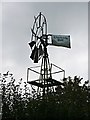
Windpump at Woodcock's Well
Most windpumps of this sort that you see around farmland are derelict but this one looks to be well maintained.
Image: © Tony Atkin
Taken: 14 Oct 2006
0.06 miles
2
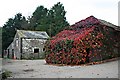
Farm Buildings in October
The closest of these buildings is covered with Boston Ivy which is giving a riot of colour on this grey October day.
Image: © Tony Atkin
Taken: 14 Oct 2006
0.12 miles
5
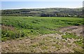
Field near Trevigro
Looking to the left from the same spot as Image], with Woodcock's Well largely hidden by trees across the field, and farmland around Appledore on the far slopes beyond the Lynher.
Image: © Derek Harper
Taken: 14 May 2014
0.14 miles
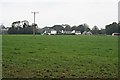
6
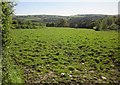
Field at Trevigro
This irregularly-shaped field slopes down from the lane from Caddapit towards the Lynher valley.
Image: © Derek Harper
Taken: 14 May 2014
0.16 miles
7
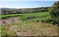
Field near Trevigro
A track curves into a field of cereals by the lane from Caddapit. Hills on the eastern side of Bodmin Moor, including Caradon Hill on the left, are across the Lynher valley. Image] looks to the left.
Image: © Derek Harper
Taken: 14 May 2014
0.21 miles