IMAGES TAKEN NEAR TO
Westover Road, CALLINGTON, PL17 7HD
Introduction
This page details the photographs taken nearby to Westover Road, PL17 7HD by members of the Geograph project.
The Geograph project started in 2005 with the aim of publishing, organising and preserving representative images for every square kilometre of Great Britain, Ireland and the Isle of Man.

There are currently over 7.5m images from over14,400 individuals and you can help contribute to the project by visiting https://www.geograph.org.uk
Image Map
Images are licensed for reuse under creativecommons.org/licenses/by-sa/2.0
Notes
- Clicking on the map will re-center to the selected point.
- The higher the marker number, the further away the image location is from the centre of the postcode.
Image Listing (38 Images Found)
Images are licensed for reuse under creativecommons.org/licenses/by-sa/2.0
Image
Details
Distance
1
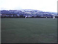
Callington Cricket Field
The New Road ground is set in the middle of town with a good view to Kit Hill to the north-east.
Image: © Trevor Rickard
Taken: Unknown
0.11 miles
2
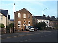
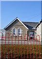
Chapel Cottage, Liskeard Road
Formerly Chapel Court, a former Plymouth Brethren chapel, see Image
Image: © Vieve Forward
Taken: 8 Sep 2023
0.12 miles

5
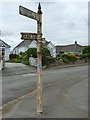
Old Direction Sign - Signpost at the dead end of St Germans Road, Callington
Cone finial - 3 arms broken; Visick by the A390, in parish of Callington (Caradon District), on the pavement on the northeast side of the "crossroads" where the A390 Southern Road crosses St Germans Road. The northern section of St Germans Road is a dead end here.
surveyed
Milestone Society National ID: CW_SX3669B
Image: © P Goodchild
Taken: 20 Sep 2012
0.16 miles
7
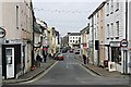
Fore Street Callington
This is Callington's main shopping street. Callington is a small town which has just about managed to hold on to a shopping area. This street widens slightly towards the church at the far end which is typical of a medieval market street, although the houses themselves appear to date mainly from the 19th century when Callington was a small industrial town as a result of nearby mining.
Image: © Tony Atkin
Taken: 14 Oct 2006
0.17 miles
8
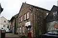
Alley off Fore Street
This narrow back alley has a number of 19th century industrial buildings converted to various commercial uses.
Image: © Tony Atkin
Taken: 14 Oct 2006
0.17 miles
9
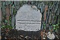
Old Boundary Marker on Saltash Road
Municipal Boundary Marker in a stone wall on the west side of Saltash Road opposite Trelawney Road. Callington parish. Inscribed (two horizontal lines) / BOROUGH (remainder hidden). A Borough Stone to mark the southern bounds of the Borough of Callington in the 17C but now entirely within the parish boundary. Grade II Listed details https://historicengland.org.uk/listing/the-list/list-entry/1140044.
Milestone Society National ID: CW_CALL02pb
Image: © S Vowden
Taken: 16 Nov 2020
0.18 miles
10
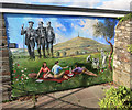
Wall Painting in Callington
Another painting on Callington's town mural trail.
Image: © Des Blenkinsopp
Taken: 28 Apr 2015
0.18 miles