IMAGES TAKEN NEAR TO
Molesworth Road, PLYMOUTH, PL1 5PF
Introduction
This page details the photographs taken nearby to Molesworth Road, PL1 5PF by members of the Geograph project.
The Geograph project started in 2005 with the aim of publishing, organising and preserving representative images for every square kilometre of Great Britain, Ireland and the Isle of Man.

There are currently over 7.5m images from over14,400 individuals and you can help contribute to the project by visiting https://www.geograph.org.uk
Image Map (Loading...)


Getting Data...Please wait
Leaflet Map data © OpenStreetMap
Images are licensed for reuse under creativecommons.org/licenses/by-sa/2.0
Notes
- Clicking on the map will re-center to the selected point.
- The higher the marker number, the further away the image location is from the centre of the postcode.
Image Listing (67 Images Found)
Images are licensed for reuse under creativecommons.org/licenses/by-sa/2.0
Image
Details
Distance
3
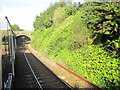
Plymouth Molesworth Road Bridge Over Railway Line
Image: © Roy Hughes
Taken: 9 Sep 2017
0.07 miles
4
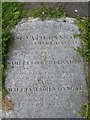
Asenath Dangar's gravestone, Stoke Damerel
This stone captivated me when I worked nearby for a few months in 2003, firstly because of the unusual name, and then because of the sad tale it tells. Asenath was the wife of Samuel Dangar. Her first son, also Samuel, died at the age of two in November 1859, by which time her second son had already died, aged 12 weeks. Asenath herself died the following summer, aged 29.
(Addendum, Oct 2019: There is now an electronic record of this headstone at http://web.plymouth.gov.uk/web.plymouth.gov.uk/homepage/creativityandculture/archives/web.plymouth.gov.uk/web.plymouth.gov.uk/web.plymouth.gov.uk/archivescatalogue?record=0&cid=mrnxyyjkp4x2yzuhzcdfvl32&criteria=Asenath%20Dangar )
The stone forms part of a path around the churchyard of St Andrew and St Luke's church; all the gravestones have been laid out in this fashion, which makes for a sombre, if fascinating, series of walkways. However, it must mean that the information upon them will be erased more quickly. I had to push back the weeds at the edge of this stone a little to reveal the lettering more clearly.
Image: © Derek Harper
Taken: 17 Jul 2008
0.09 miles
5
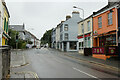
Molesworth Road approaching Wilton Road and Wilton Street
Image: © Mark Anderson
Taken: 30 Jun 2023
0.10 miles
7
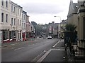
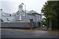
Millbridge
This area of Plymouth is called Millbridge and is centred on this traffic light controlled crossroads. Around the crossroads can be found the usual local shops and services including a pub, mini-mart, take-away and several second-hand shops. The mill bridge after which this area is named was at the bottom of the hill on the road in the distance but the mills have long since vanished and the tidal creek the road crossed filled in to become a park Image
Image: © Tony Atkin
Taken: 29 Jul 2005
0.10 miles