IMAGES TAKEN NEAR TO
Stuart Road, PLYMOUTH, PL1 5LP
Introduction
This page details the photographs taken nearby to Stuart Road, PL1 5LP by members of the Geograph project.
The Geograph project started in 2005 with the aim of publishing, organising and preserving representative images for every square kilometre of Great Britain, Ireland and the Isle of Man.

There are currently over 7.5m images from over14,400 individuals and you can help contribute to the project by visiting https://www.geograph.org.uk
Image Map
Images are licensed for reuse under creativecommons.org/licenses/by-sa/2.0
Notes
- Clicking on the map will re-center to the selected point.
- The higher the marker number, the further away the image location is from the centre of the postcode.
Image Listing (136 Images Found)
Images are licensed for reuse under creativecommons.org/licenses/by-sa/2.0
Image
Details
Distance
1

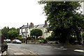
Road Junction
Apartments on the Alma Road.
Image: © Robert Ashby
Taken: 5 Aug 2015
0.03 miles
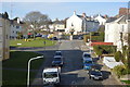
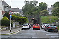
2
Stuart Road
Houses in Stoke, Devonport.
Image: © Robert Ashby
Taken: 5 Aug 2015
0.05 miles
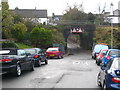
3

Railway Crossing Stuart Road Pennycomequick Plymouth
Image: © Roy Hughes
Taken: 9 Sep 2017
0.08 miles
4
Railway bridge in De-La-Hay Avenue
Carrying the Paddington-Penzance mainline though Plymouth's suburbs.
Image: © Rod Allday
Taken: 17 Nov 2010
0.08 miles
6
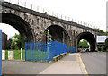
Railway Viaduct, Stuart Road
View west under the GWR viaduct. The brick piers of the former branch to the dockyard (see Image) can be seen through the two left-most arches.
Image: © Pierre Terre
Taken: 29 May 2008
0.09 miles