IMAGES TAKEN NEAR TO
Palmerston Street, PLYMOUTH, PL1 5LL
Introduction
This page details the photographs taken nearby to Palmerston Street, PL1 5LL by members of the Geograph project.
The Geograph project started in 2005 with the aim of publishing, organising and preserving representative images for every square kilometre of Great Britain, Ireland and the Isle of Man.

There are currently over 7.5m images from over14,400 individuals and you can help contribute to the project by visiting https://www.geograph.org.uk
Image Map
Images are licensed for reuse under creativecommons.org/licenses/by-sa/2.0
Notes
- Clicking on the map will re-center to the selected point.
- The higher the marker number, the further away the image location is from the centre of the postcode.
Image Listing (67 Images Found)
Images are licensed for reuse under creativecommons.org/licenses/by-sa/2.0
Image
Details
Distance
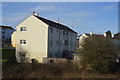
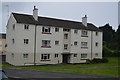
1
Terrace of Large Victorian Houses
Stuart Road, Stoke, Plymouth. Many of these houses are now divided into flats.
Image: © Tony Atkin
Taken: 8 Jan 2006
0.04 miles
2
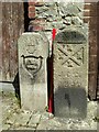
Old Boundary Markers in back Wilton Street, Plymouth
Two Municipal Boundary Markers against the rear wall of a house in the back lane of Wilton Street, Plymouth.
On the left is Devonport municipal borough boundary marker DV_DCBB14pb. Inscribed D.C. B. / St LEVAN / MAYOR / 1891. St Levan was The Right Honourable John, Lord Saint Levan.
On the right is Plymouth borough boundary marker DV_PCBS15pb. Inscribed VII / J.C.C. / 1840. J.C.C. refers to Joseph C Cookworthy, mayor.
Image: © T Jenkinson
Taken: 16 May 2012
0.09 miles
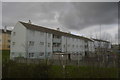
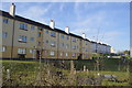
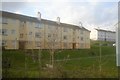
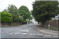
3
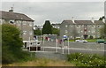
Houses off Wingfield Road
There a number of blocks of houses, or maybe flats, in this area, each three storeys high. They back on to the railway line to the west of Plymough station, in an area called Stoke.
This photo was taken from the 1158 Penzance to London Paddington train, having left Liskeard at 1332 and shortly to arrive at Plymouth.
Image: © Graham Horn
Taken: 9 Jul 2011
0.10 miles