IMAGES TAKEN NEAR TO
St. Giles-on-the-Heath, LAUNCESTON, PL15 9SU
Introduction
This page details the photographs taken nearby to PL15 9SU by members of the Geograph project.
The Geograph project started in 2005 with the aim of publishing, organising and preserving representative images for every square kilometre of Great Britain, Ireland and the Isle of Man.

There are currently over 7.5m images from over14,400 individuals and you can help contribute to the project by visiting https://www.geograph.org.uk
Image Map (Loading...)


Getting Data...Please wait
Leaflet Map data © OpenStreetMap
Images are licensed for reuse under creativecommons.org/licenses/by-sa/2.0
Notes
- Clicking on the map will re-center to the selected point.
- The higher the marker number, the further away the image location is from the centre of the postcode.
Image Listing (2 Images Found)
Images are licensed for reuse under creativecommons.org/licenses/by-sa/2.0
Image
Details
Distance
1
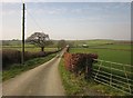
Lane to Pinslow
The lane from Box's Shop descending towards the valley of a tiny tributary of the Tamar. At the barn and cottages, the lane swings sharply left while the farm track to Pinslow continues ahead.
Image: © Derek Harper
Taken: 2 Mar 2012
0.14 miles
2
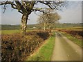
Lane near East Park
Oaks by the lane to Pinslow, with verge and ditch by the lane. The white cottages are at Brookside.
Image: © Derek Harper
Taken: 2 Mar 2012
0.24 miles