IMAGES TAKEN NEAR TO
Pinslow Cross, LAUNCESTON, PL15 9SB
Introduction
This page details the photographs taken nearby to Pinslow Cross, PL15 9SB by members of the Geograph project.
The Geograph project started in 2005 with the aim of publishing, organising and preserving representative images for every square kilometre of Great Britain, Ireland and the Isle of Man.

There are currently over 7.5m images from over14,400 individuals and you can help contribute to the project by visiting https://www.geograph.org.uk
Image Map (Loading...)


Getting Data...Please wait
Leaflet Map data © OpenStreetMap
Images are licensed for reuse under creativecommons.org/licenses/by-sa/2.0
Notes
- Clicking on the map will re-center to the selected point.
- The higher the marker number, the further away the image location is from the centre of the postcode.
Image Listing (4 Images Found)
Images are licensed for reuse under creativecommons.org/licenses/by-sa/2.0
Image
Details
Distance
1
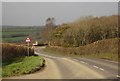
A388 at Hawkadon
Looking in the other direction along the main road shown in Image, as it rounds a small wood on a slight descent towards St Giles on The Heath.
Image: © Derek Harper
Taken: 2 Mar 2012
0.12 miles
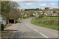
3
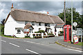
St Giles on the Heath: The Pint & Post
A pub and rural post office combined. By the Holsworthy-Launceston road. Looking north east
Image: © Martin Bodman
Taken: 28 May 2007
0.25 miles
4
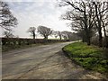
A388 at Hawkadon
The oaks left of centre are by the farm road into Hawkadon Farm.
Image: © Derek Harper
Taken: 2 Mar 2012
0.25 miles