IMAGES TAKEN NEAR TO
Werrington, LAUNCESTON, PL15 9RP
Introduction
This page details the photographs taken nearby to PL15 9RP by members of the Geograph project.
The Geograph project started in 2005 with the aim of publishing, organising and preserving representative images for every square kilometre of Great Britain, Ireland and the Isle of Man.

There are currently over 7.5m images from over14,400 individuals and you can help contribute to the project by visiting https://www.geograph.org.uk
Image Map
Images are licensed for reuse under creativecommons.org/licenses/by-sa/2.0
Notes
- Clicking on the map will re-center to the selected point.
- The higher the marker number, the further away the image location is from the centre of the postcode.
Image Listing (7 Images Found)
Images are licensed for reuse under creativecommons.org/licenses/by-sa/2.0
Image
Details
Distance
1
Cattle near Bridgetown
Cattle taking life easy in a field on the edge of the Tamar valley. behind them, the Tala Water valley joins the Tamar, but Dark's Wood, to the left, is in SX3489.
Image: © Derek Harper
Taken: 9 Nov 2007
0.04 miles
2
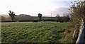
Field near Bridgetown
A field of winter cereal, taken through a gateway past a no-nonsense wall, on footpath 563/6/1 from Mountshire to Bridgetown. At the lower end of the field is Image
Image: © Derek Harper
Taken: 9 Nov 2007
0.07 miles
3
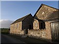
Siloam Bible Christian Chapel and Sunday School, Bridgetown
I failed to take proper note of the tablet on the gable, but the date of construction is, I think, sometime in the 1860s. This is, as is usual, in an isolated position, on the lane to Crossgate a little south of Bridgetown.
Image: © Derek Harper
Taken: 9 Nov 2007
0.13 miles
4
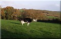
Field above Bridgetown
That cow needs milking! On the far side of the field (viewed from the lane between Wilkie Down Farm and Bridgetown), oak trees occupy a small short valley which descends to the right to the Tamar.
Image: © Derek Harper
Taken: 9 Nov 2007
0.14 miles
5
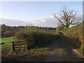
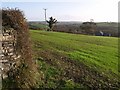
Track to Mountshire
Footpath 563/6/1 follows this track from Bridgetown, gently dropping towards the Tala Water valley in the background.
Image: © Derek Harper
Taken: 9 Nov 2007
0.14 miles
6
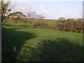
Field above Bridgetown
A view to the left of Image, roughly contiguous, with trees in the same small valley beyond the field, and a couple of hedgerow oaks.
Image: © Derek Harper
Taken: 9 Nov 2007
0.20 miles
7
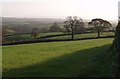
Field above Bridgetown
Another view across the field shown in Image, looking to the right, and the trees on the right can be seen in Image From this direction, the Tamar valley looks merely a dip between interlocking spurs. In the far distance, beside a small wood, are houses at Box's Shop in SX3589.
Image: © Derek Harper
Taken: 9 Nov 2007
0.21 miles