IMAGES TAKEN NEAR TO
Lawhitton, LAUNCESTON, PL15 9NG
Introduction
This page details the photographs taken nearby to PL15 9NG by members of the Geograph project.
The Geograph project started in 2005 with the aim of publishing, organising and preserving representative images for every square kilometre of Great Britain, Ireland and the Isle of Man.

There are currently over 7.5m images from over14,400 individuals and you can help contribute to the project by visiting https://www.geograph.org.uk
Image Map
Images are licensed for reuse under creativecommons.org/licenses/by-sa/2.0
Notes
- Clicking on the map will re-center to the selected point.
- The higher the marker number, the further away the image location is from the centre of the postcode.
Image Listing (6 Images Found)
Images are licensed for reuse under creativecommons.org/licenses/by-sa/2.0
Image
Details
Distance
1
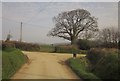
Lane junction, Lawhitton Barton
The lane from Lawhitton to Carzantic swings left here, witrh the entrance to Lawhitton Barton on the right. The lane is followed by the Tamar Valley Discovery Trail.
Image: © Derek Harper
Taken: 2 Mar 2012
0.04 miles
2
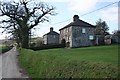
Semis in the Countryside
These houses are close to a farm but otherwise in the middle of the countryside. They may have originally been built as farmworkers houses.
Image: © Tony Atkin
Taken: 3 Feb 2007
0.04 miles
3
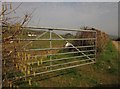
Gateway, Lawhitton Barton
Catkins herald spring by this gate on the lane to Carzantic, visible in the background.
Image: © Derek Harper
Taken: 2 Mar 2012
0.07 miles
5
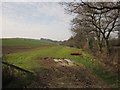
Field near Carzantic
A view alongside the tiny stream that runs along the valley from which Image was taken.
Image: © Derek Harper
Taken: 2 Mar 2012
0.21 miles
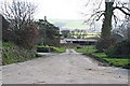
6
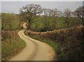
Lane to Carzantic
A similar view to Image, with the lane from Lawhitton crossing a small tributary valley of the Tamar.
Image: © Derek Harper
Taken: 2 Mar 2012
0.23 miles