IMAGES TAKEN NEAR TO
Downinney, LAUNCESTON, PL15 8UR
Introduction
This page details the photographs taken nearby to PL15 8UR by members of the Geograph project.
The Geograph project started in 2005 with the aim of publishing, organising and preserving representative images for every square kilometre of Great Britain, Ireland and the Isle of Man.

There are currently over 7.5m images from over14,400 individuals and you can help contribute to the project by visiting https://www.geograph.org.uk
Image Map (Loading...)


Getting Data...Please wait
Leaflet Map data © OpenStreetMap
Images are licensed for reuse under creativecommons.org/licenses/by-sa/2.0
Notes
- Clicking on the map will re-center to the selected point.
- The higher the marker number, the further away the image location is from the centre of the postcode.
Image Listing (5 Images Found)
Images are licensed for reuse under creativecommons.org/licenses/by-sa/2.0
Image
Details
Distance
1
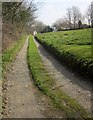
Track, Downinney
Veering off from the lane on the other side of the green at this hamlet which forms part of Warbstow.
Image: © Derek Harper
Taken: 18 Mar 2015
0.05 miles
2
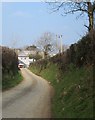
Lane to Downinney
Image: © Derek Harper
Taken: 18 Mar 2015
0.10 miles
3
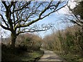
Lane to Warbstow Cross
From the north corner of the green at Downinney, with a belt of trees on the right.
Image: © Derek Harper
Taken: 18 Mar 2015
0.12 miles
4
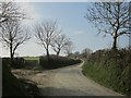
Lane to Tredarrup Cross
From a junction near Downinney. On a left is a track leading to several otherwise inaccessible fields. However, a sturdy barrier on the left implies that access is discouraged.
Image: © Derek Harper
Taken: 18 Mar 2015
0.18 miles
5
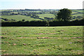
Warbstow: near Lower Town
Field path to Nether Scarsick. The hamlet of Treneglos is hidden in the group of trees near the skyline
Image: © Martin Bodman
Taken: 15 Sep 2007
0.24 miles