IMAGES TAKEN NEAR TO
Attery View, LAUNCESTON, PL15 8TY
Introduction
This page details the photographs taken nearby to Attery View, PL15 8TY by members of the Geograph project.
The Geograph project started in 2005 with the aim of publishing, organising and preserving representative images for every square kilometre of Great Britain, Ireland and the Isle of Man.

There are currently over 7.5m images from over14,400 individuals and you can help contribute to the project by visiting https://www.geograph.org.uk
Image Map
Images are licensed for reuse under creativecommons.org/licenses/by-sa/2.0
Notes
- Clicking on the map will re-center to the selected point.
- The higher the marker number, the further away the image location is from the centre of the postcode.
Image Listing (10 Images Found)
Images are licensed for reuse under creativecommons.org/licenses/by-sa/2.0
Image
Details
Distance
1
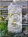
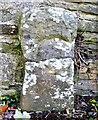
Old Boundary Marker
County Bridge Marker on the south side of the minor road to Wringsdown, 100 metres northwest of Yeolm Bridge, River Ottery. Werrington parish, formerly Devon, now Cornwall. Inscribed C. The stone marks the extent of roadway adjoining the bridge that the County was obliged to maintain. Grade II Listed details https://historicengland.org.uk/listing/the-list/list-entry/1328067.
Milestone Society National ID: CW_WERR01br
Image: © R Hanns
Taken: 14 Sep 2019
0.05 miles
2
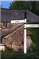
Old Direction Sign - Signpost by the B3254, Yeolmbridge
Spindle finial - Recently refurbished with NEW finial; by the B3254, in parish of St Stephens by Launceston Rural (North Cornwall District), Yeolmbridge, North of bridge, East side of road.
Cornwall and Scilly HER.
HER Number: MCO57747 https://www.heritagegateway.org.uk/Gateway/Results_Single.aspx?uid=MCO57747&resourceID=1020
Surveyed
Milestone Society National ID: CW_SX3187
Image: © Milestone Society
Taken: Unknown
0.10 miles
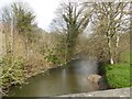
3
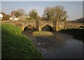
Yeolm Bridge
See also Image The bridge spans the River Ottery (this is the upstream side), and has been described as the "oldest and most perfectly finished bridge in Cornwall" http://www.britishlistedbuildings.co.uk/en-68058-yeolm-bridge-werrington .
Image: © Derek Harper
Taken: 2 Mar 2012
0.10 miles
5
Old Boundary Marker
County Bridge Marker on the east side of the B3254 100 metres northeast of Yeolm Bridge, River Ottery. Werrington parish, formerly Devon, now Cornwall. Inscribed C. The stone marks the extent of roadway adjoining the bridge that the County was obliged to maintain. Grade II Listed details https://historicengland.org.uk/listing/the-list/list-entry/1328068.
Milestone Society National ID: CW_WERR02br
Image: © R Hanns
Taken: 14 Sep 2019
0.11 miles
7

Crossing the Ottery at Yeolmbridge
Crossing the River Ottery, a tributary of the Tamar, at Yeolmbridge.
Image: © Peter Kazmierczak
Taken: 12 Aug 2010
0.12 miles
8
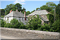
Werrington: at Yeolmbridge
The bridge crosses the river Ottery, a Tamar tributary. A long leat from the river powered Yeolmbridge Mill, the building with the slate roof and end wall covered in ivy. Looking east-north-east
Image: © Martin Bodman
Taken: 5 Jun 2007
0.13 miles
9

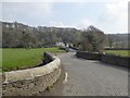
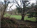
Werrington: Yeolmbridge
Looking south on the B3254 in the Launceston direction, the road crossing the Ottery flood plain
Image: © Martin Bodman
Taken: 5 Jun 2007
0.13 miles
10
View from the old reading room
Showing the River Ottery (taken from the north bank)
Image: © Jeremiah
Taken: 7 Feb 2015
0.17 miles