IMAGES TAKEN NEAR TO
Peppers Hill Close, LAUNCESTON, PL15 8TF
Introduction
This page details the photographs taken nearby to Peppers Hill Close, PL15 8TF by members of the Geograph project.
The Geograph project started in 2005 with the aim of publishing, organising and preserving representative images for every square kilometre of Great Britain, Ireland and the Isle of Man.

There are currently over 7.5m images from over14,400 individuals and you can help contribute to the project by visiting https://www.geograph.org.uk
Image Map
Images are licensed for reuse under creativecommons.org/licenses/by-sa/2.0
Notes
- Clicking on the map will re-center to the selected point.
- The higher the marker number, the further away the image location is from the centre of the postcode.
Image Listing (8 Images Found)
Images are licensed for reuse under creativecommons.org/licenses/by-sa/2.0
Image
Details
Distance
1
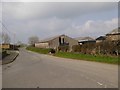
Barn on minor road north from Ladycross
Image: © David Smith
Taken: 15 Apr 2016
0.03 miles
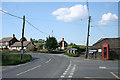
2

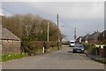
Approaching Ladycross
Approaching the outskirts of Ladycross village, situated on the B3254 road.
Image: © Peter Kazmierczak
Taken: 12 Aug 2010
0.03 miles
3
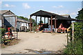
Werrington: farm at Ladycross
Looking east-south-east
Image: © Martin Bodman
Taken: 5 Jun 2007
0.05 miles
4
Werrington: Ladycross
A bend in the B3254, the road to Bude and Kilkhampton from Launceston. Looking north
Image: © Martin Bodman
Taken: 5 Jun 2007
0.07 miles
5
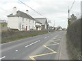
The B3254 through Ladycross
Beyond the white-painted house, the Methodist chapel is dated 1879.
Image: © John Baker
Taken: 29 Mar 2013
0.08 miles
7
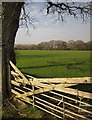
Field near Ladycross
A field in between the hamlet of Ladycross and Image, seen from the road from Werrington, with woodland on the far side.
Image: © Derek Harper
Taken: 2 Mar 2012
0.19 miles
8
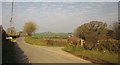
Junction near Ladycross
A lane to Eggbeare leaves the road to Bullapit; both are heading for the Tale Water valley.
Image: © Derek Harper
Taken: 2 Mar 2012
0.20 miles