IMAGES TAKEN NEAR TO
Egloskerry, LAUNCESTON, PL15 8SU
Introduction
This page details the photographs taken nearby to PL15 8SU by members of the Geograph project.
The Geograph project started in 2005 with the aim of publishing, organising and preserving representative images for every square kilometre of Great Britain, Ireland and the Isle of Man.

There are currently over 7.5m images from over14,400 individuals and you can help contribute to the project by visiting https://www.geograph.org.uk
Image Map
Images are licensed for reuse under creativecommons.org/licenses/by-sa/2.0
Notes
- Clicking on the map will re-center to the selected point.
- The higher the marker number, the further away the image location is from the centre of the postcode.
Image Listing (6 Images Found)
Images are licensed for reuse under creativecommons.org/licenses/by-sa/2.0
Image
Details
Distance
1
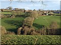
Badharlick
A view of the hamlet across a tributary valley of the Kensey from the footpath along the track shown in Image The band of trees in line with the camera hides a track down to a footbridge across the stream.
Image: © Derek Harper
Taken: 4 Mar 2008
0.14 miles
2
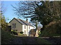
Cottage below Badharlick
Kylamry is on footpath 511/1/1 as it climbs from the ford across the Amry River.
Image: © Derek Harper
Taken: 4 Mar 2008
0.16 miles
3
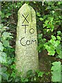
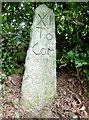
Old Milestone east of Badharlick
Carved stone post by the UC road, in parish of EGLOSKERRY (CARADON District), above Badharlick Mill, on top of hedge bank, on South side of road. Rough granite, erected by the parish in the 21st century.
Inscription reads:-
XI
To
Cam
Milestone Society National ID: CW_CFWB11R.
Image: © Ian Thompson
Taken: 10 Aug 2012
0.16 miles
4
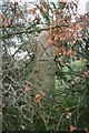
Old Milestone west of Badharlick Mill, Egloskerry Parish
Milestone in parish of Egloskerry (Caradon District), West of Badharlick Mill, South side of road, on top of hedge, hidden by summer growth.
Cornwall & Scilly HER.
HER Number: MCO55425 https://www.heritagegateway.org.uk/Gateway/Results_Single.aspx?uid=MCO55425&resourceID=1020
Lost since 2010 and replaced with a facsimile: https://www.geograph.org.uk/photo/6390950
Milestone Society National ID: CW_CFWB11
Image: © Milestone Society
Taken: Unknown
0.16 miles
5
Replica Milestone by the A39, east of Badharlick
Carved stone post by the A39, in parish of EGLOSKERRY (CARADON District), above Badharlick Mill, on top of hedge bank, on South side of road. Rough granite - a facsimile erected by the parish in the 21st century to replace a 'lost' old stone: https://www.geograph.org.uk/photo/6043688
Inscription reads:-
XI
To
Cam
Cornwall & Scilly HER.
HER Number: MCO56434 https://www.heritagegateway.org.uk/Gateway/Results_Single.aspx?uid=MCO56434&resourceID=1020
Milestone Society National ID: CW_CFWB11R.
Image: © Rosy Hanns
Taken: 23 Jun 2019
0.16 miles
6
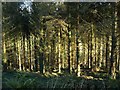
Woodland near Badharlick
The conifer wood beside which footpath 511/1/1 runs, on the slopes of a tributary of the Kensey.
Image: © Derek Harper
Taken: 4 Mar 2008
0.25 miles