IMAGES TAKEN NEAR TO
Culvers Meadow, LAUNCESTON, PL15 8RR
Introduction
This page details the photographs taken nearby to Culvers Meadow, PL15 8RR by members of the Geograph project.
The Geograph project started in 2005 with the aim of publishing, organising and preserving representative images for every square kilometre of Great Britain, Ireland and the Isle of Man.

There are currently over 7.5m images from over14,400 individuals and you can help contribute to the project by visiting https://www.geograph.org.uk
Image Map (Loading...)


Getting Data...Please wait
Leaflet Map data © OpenStreetMap
Images are licensed for reuse under creativecommons.org/licenses/by-sa/2.0
Notes
- Clicking on the map will re-center to the selected point.
- The higher the marker number, the further away the image location is from the centre of the postcode.
Image Listing (15 Images Found)
Images are licensed for reuse under creativecommons.org/licenses/by-sa/2.0
Image
Details
Distance
1
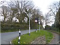
Cross Lanes, St Stephens
The footpath drops to give a safe refuge for pedestrians crossing the Roydon Road
Image: © David Smith
Taken: 15 Apr 2016
0.13 miles
2
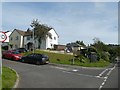
Bus shelter on Roydon Road, Launceston, by Broad Park
Image: © David Smith
Taken: 7 Sep 2020
0.14 miles
3
Launceston from Saint Stephens Hill 1973
Taken from about half way up Saint Stephens Hill. Original on Boots colourslide film using Agfa Silette 35mm camera
Image: © Crispin Purdye
Taken: Unknown
0.16 miles
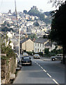
4
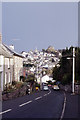
Launceston from Saint Stephens Hill, 2007
The valley between St Stephens and the centre of Launceston is very steep and would keep you fit if you had to walk it every day. The road down this hill has become inadequate for the volume of traffic it has to take so through traffic going downhill has been diverted to another route leaving just uphill traffic in low gear.
Image: © Tony Atkin
Taken: 25 Jan 2007
0.17 miles
5
Launceston: northern suburbs
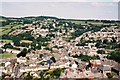
Looking over Newtown and St. Stephen’s from the castle tower.
Image: © Chris Downer
Taken: 8 Aug 2005
0.18 miles
6
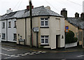
Tollhouse by the B3254, St Stephen's Hill, St Stephens
Tollhouse by the B3254, in the parish of St. Stephens by Launceston Rural (North Cornwall District), The Toll House, No. 48, St Stephen's Hill, PL15 8HU.
Grade II listed.
List Entry Number: 1355134 https://historicengland.org.uk/listing/the-list/list-entry/1355134
Surveyed
Milestone Society National ID: CW.SSL01
Image: © Alan Rosevear
Taken: 30 Sep 2008
0.20 miles
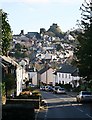
7
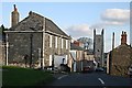
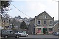
St Stephens
St Stephens is a village which has become contiguous with the town of Launceston although the river Kensey valley separating St Stephens from the centre of Launceston is very steep at this point. This photo looks along Duke Street to the parish church.
Image: © Tony Atkin
Taken: 25 Jan 2007
0.21 miles
8
St Stepthen's Hill leading into Launceston
Image: © Colin Park
Taken: 15 Sep 1983
0.21 miles
9
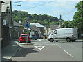
The B3284 joining the A388 at Launceston
Image: © Roy Hughes
Taken: 31 Aug 2022
0.21 miles
10
Spar shop, Dutson Road
Behind the shop is a distant view of the castle at Launceston
Image: © David Smith
Taken: 15 Apr 2016
0.21 miles