IMAGES TAKEN NEAR TO
LAUNCESTON, PL15 8HU
Introduction
This page details the photographs taken nearby to PL15 8HU by members of the Geograph project.
The Geograph project started in 2005 with the aim of publishing, organising and preserving representative images for every square kilometre of Great Britain, Ireland and the Isle of Man.

There are currently over 7.5m images from over14,400 individuals and you can help contribute to the project by visiting https://www.geograph.org.uk
Image Map
Images are licensed for reuse under creativecommons.org/licenses/by-sa/2.0
Notes
- Clicking on the map will re-center to the selected point.
- The higher the marker number, the further away the image location is from the centre of the postcode.
Image Listing (47 Images Found)
Images are licensed for reuse under creativecommons.org/licenses/by-sa/2.0
Image
Details
Distance
1
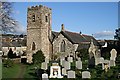
St Thomas Church
This parish church sits in the valley of the River Kensey below the steep hill leading up to Launceston town centre. It began life associated with an early medieval abbey and hospital and was restored in 1871.
Image: © Tony Atkin
Taken: 25 Jan 2007
0.03 miles
2
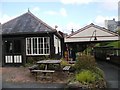
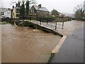
Riverside, Launceston
Taken from in between St Thomas' bridge and church; the churchyard is on the left. The development of 21 houses and flats at Riverside Mills, where the road becomes Town Mills, was completed in 2007.
Image: © Derek Harper
Taken: 23 Nov 2009
0.03 miles
3
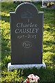
The Grave of Charles Causley in St Thomas Churchyard
Charles Causley was one of the country's most highly regarded poets but he remained rather unfashionable, perhaps because of his love of writing poetry for children and of the ballad form. He lived most of his life in Launceston, the town where he was born and is buried.
"All poetry is magic. It is a spell against insensitivity, failure of imagination, ignorance and barbarism." - Charles Causley
Image: © Tony Atkin
Taken: 25 Jan 2007
0.05 miles
5
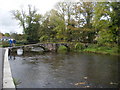
Prior's Bridge, Launceston
The level of the water is more clearly shown without sunshine - compare Image, taken nearly an hour and a half later. The height in relation to the right-hand arches can be compared with Image
There seems to be confusion about the name of the bridge. The most detailed OS map has "St Thomas Bridge", and the listed building description states "West Bridge RIVERSIDE. Also known as: St Thomas Bridge" http://www.imagesofengland.org.uk/details/default.aspx?id=370137 . But this would surely confuse with http://www.imagesofengland.org.uk/Details/Default.aspx?id=370111&mode=adv , where the nearby road bridge is also called "St Thomas's Bridge". http://www.historic-cornwall.org.uk/csus/towns/launceston/csus_launceston_report_2005R051.pdf gives "Prior's Bridge".
Image: © Derek Harper
Taken: 23 Nov 2009
0.08 miles
6
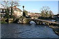
Prior's Bridge and the River Kensey
An ancient bridge over the river in Launceston.
Image: © Tony Atkin
Taken: 25 Jan 2007
0.08 miles
7
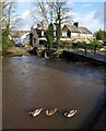
Prior's Bridge, Launceston
These mallards are happy that the Kensey is high and there is more river to swim in. Compare the level with Image, where the white mark on the central support is a couple of feet above the water. http://www.imagesofengland.org.uk/details/default.aspx?id=370137 (but see Image)
Image: © Derek Harper
Taken: 23 Nov 2009
0.08 miles
8
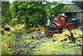
Launceston: Launceston Steam Railway
Narrow-gauge locomotive ‘Covercoat’, built by Hunslet of Leeds, near the railway’s workshops. The tourist line utilises the old Southern Railway route from Exeter to North Cornwall
Image: © Martin Bodman
Taken: Unknown
0.08 miles
9
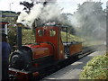
"Covertcoat" at Launceston Steam Railway Cornwall
Looking South West at "Covertcoat" steaming idly at Launceston Station.
Image: © Richard Dunn
Taken: 11 Sep 2003
0.09 miles