IMAGES TAKEN NEAR TO
Newport Square, LAUNCESTON, PL15 8EL
Introduction
This page details the photographs taken nearby to Newport Square, PL15 8EL by members of the Geograph project.
The Geograph project started in 2005 with the aim of publishing, organising and preserving representative images for every square kilometre of Great Britain, Ireland and the Isle of Man.

There are currently over 7.5m images from over14,400 individuals and you can help contribute to the project by visiting https://www.geograph.org.uk
Image Map
Images are licensed for reuse under creativecommons.org/licenses/by-sa/2.0
Notes
- Clicking on the map will re-center to the selected point.
- The higher the marker number, the further away the image location is from the centre of the postcode.
Image Listing (45 Images Found)
Images are licensed for reuse under creativecommons.org/licenses/by-sa/2.0
Image
Details
Distance
1
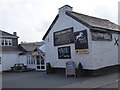
The White Horse Inn and its advertising
The lower board advertises that this is "Lanson's best Sunday carvery" using the traditional pronunciation of the town's name
Image: © David Smith
Taken: 15 Apr 2016
0.01 miles
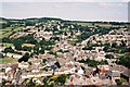
2
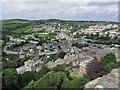
Launceston - View NNW from top of Castle Keep over suburb of Newport
Image: © Colin Park
Taken: 12 Aug 2014
0.02 miles
3
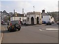
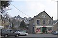
Newport Round House, built in 1829
Described in http://www.launcestonthen.co.uk/newportroundhouse.html
Image: © David Smith
Taken: 15 Apr 2016
0.03 miles
4
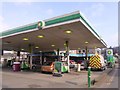
BP filling station in Newport, Launceston
Image: © David Smith
Taken: 15 Apr 2016
0.03 miles
5
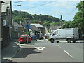
The B3284 joining the A388 at Launceston
Image: © Roy Hughes
Taken: 31 Aug 2022
0.03 miles
6
Spar shop, Dutson Road
Behind the shop is a distant view of the castle at Launceston
Image: © David Smith
Taken: 15 Apr 2016
0.04 miles
7
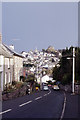
St Stepthen's Hill leading into Launceston
Image: © Colin Park
Taken: 15 Sep 1983
0.05 miles
8
Launceston: northern suburbs
Looking over Newtown and St. Stephen’s from the castle tower.
Image: © Chris Downer
Taken: 8 Aug 2005
0.06 miles
9
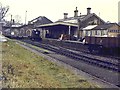
The closed GWR station at Launceston
The former GWR station at Launceston, originally built as the terminus of the line from Plymouth. The Southern Railway later built a station serving their North Cornwall line next to it. In 1952 WR trains were diverted to the SR station, and the GWR station closed to passengers.
Image: © Richard Green
Taken: 16 Dec 1962
0.06 miles
10
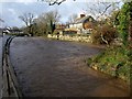
River Kensey
The swollen river seen from Riverside just west of St Thomas Road, with the upstream tip of an island on the right, and Image just keeping above the water level.
Image: © Derek Harper
Taken: 23 Nov 2009
0.06 miles