IMAGES TAKEN NEAR TO
Polyphant, LAUNCESTON, PL15 7PT
Introduction
This page details the photographs taken nearby to PL15 7PT by members of the Geograph project.
The Geograph project started in 2005 with the aim of publishing, organising and preserving representative images for every square kilometre of Great Britain, Ireland and the Isle of Man.

There are currently over 7.5m images from over14,400 individuals and you can help contribute to the project by visiting https://www.geograph.org.uk
Image Map (Loading...)


Getting Data...Please wait
Leaflet Map data © OpenStreetMap
Images are licensed for reuse under creativecommons.org/licenses/by-sa/2.0
Notes
- Clicking on the map will re-center to the selected point.
- The higher the marker number, the further away the image location is from the centre of the postcode.
Image Listing (18 Images Found)
Images are licensed for reuse under creativecommons.org/licenses/by-sa/2.0
Image
Details
Distance
2
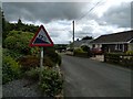
The east-west road through Polyphant
Most of the houses in the village are to the south of this road, along the two roads which approach the settlement from south-east and south-west. There are what appear to be gravestones on the verge to the right.
Image: © David Smith
Taken: 18 Jan 2014
0.03 miles
3
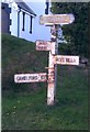
Direction Sign - Signpost by Polyphant Chapel, Lewannick
Pyramid finial - Two poor arm repairs; by the UC road, in parish of Lewannick (North Cornwall District), in front of Polyphant Chapel.
Surveyed
Milestone Society National ID: CW_SX2682
Image: © Milestone Society
Taken: Unknown
0.06 miles
4
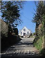
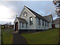
Polyphant Methodist Church
The lane from the green climbs to a T junction in front of the church Image The church may date from 1887 http://crocat.cornwall.gov.uk/DServe/dserve.exe?dsqIni=Dserve.ini&dsqApp=Archive&dsqDb=Persons&dsqSearch=Code==%27CRO%2FUK%2F786%27&dsqCmd=Show.tcl .
Image: © Derek Harper
Taken: 14 Apr 2015
0.07 miles
5
Polyphant Methodist Church and churchyard
It is also referred to as Polyphant Chapel without reference to the denomination
Image: © David Smith
Taken: 18 Jan 2014
0.08 miles
6
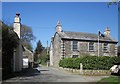
Listed house, Polyphant
Overlooking the green, and described at http://list.historicengland.org.uk/resultsingle.aspx?uid=1249300&searchtype=mapsearch . The lane continues uphill to the church.
Image: © Derek Harper
Taken: 14 Apr 2015
0.09 miles
7
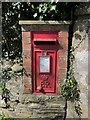
Postbox, Polyphant
Elizabeth II postbox PL15 115 can also be seen in Image
Image: © Derek Harper
Taken: 14 Apr 2015
0.10 miles
8
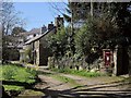
The Row, Polyphant
The terrace of three cottages, described at http://list.historicengland.org.uk/resultsingle.aspx?uid=1277520&searchtype=mapsearch , is also visible up the green at Image The Elizabeth II postbox is number PL15 115.
Image: © Derek Harper
Taken: 14 Apr 2015
0.11 miles
9
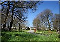
Polyphant Green
Looking idyllic on a glorious spring day, with flowers everywhere among the trees and grass. The K6 telephone box is listed http://list.historicengland.org.uk/resultsingle.aspx?uid=1249380&searchtype=mapsearch , as is the house behind it http://list.historicengland.org.uk/resultsingle.aspx?uid=1249300&searchtype=mapsearch .
Image: © Derek Harper
Taken: 14 Apr 2015
0.11 miles
10
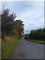
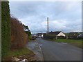
Polyphant seen from the west
The road from the west, at the outskirts of the village
Image: © David Smith
Taken: 18 Jan 2014
0.12 miles