IMAGES TAKEN NEAR TO
LAUNCESTON, PL15 7BW
Introduction
This page details the photographs taken nearby to PL15 7BW by members of the Geograph project.
The Geograph project started in 2005 with the aim of publishing, organising and preserving representative images for every square kilometre of Great Britain, Ireland and the Isle of Man.

There are currently over 7.5m images from over14,400 individuals and you can help contribute to the project by visiting https://www.geograph.org.uk
Image Map (Loading...)


Getting Data...Please wait
Leaflet Map data © OpenStreetMap
Images are licensed for reuse under creativecommons.org/licenses/by-sa/2.0
Notes
- Clicking on the map will re-center to the selected point.
- The higher the marker number, the further away the image location is from the centre of the postcode.
Image Listing (37 Images Found)
Images are licensed for reuse under creativecommons.org/licenses/by-sa/2.0
Image
Details
Distance
1
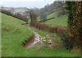
Footpath, Launceston
Footpath 520/1/1 runs along the valley shown in Image, below the remains of the town walls.
Image: © Derek Harper
Taken: 23 Nov 2009
0.10 miles
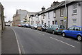
2
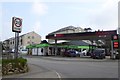
Texaco filling station and Co-op shop, Western Road, Launceston
Image: © David Smith
Taken: 15 Apr 2016
0.10 miles
3
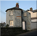
Chapple Tollhouse by Westgate Street, Launceston
Tollhouse by the A388, in the parish of Launceston (North Cornwall District), No. 34, Westgate Street.
Cornwall & Scilly HER.
HER Number: 176818 https://www.heritagegateway.org.uk/Gateway/Results_Single.aspx?uid=MCO52627&resourceID=1020
Surveyed
Milestone Society National ID: CW.LAU02
Image: © Alan Rosevear
Taken: 19 Feb 2008
0.11 miles
4
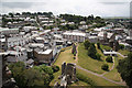
Launceston
Launceston roofscape from the castle keep
Image: © Richard Croft
Taken: 2 Jul 2010
0.13 miles
5
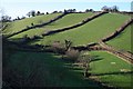
Green Valley by Launceston
Although surrounded on three sides by urban development, this valley remains purely agricultural. It stretches from the St Thomas district at the lower end to the Chapel district of Launceston at the upper end.
Image: © Tony Atkin
Taken: 25 Jan 2007
0.13 miles
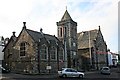
7
Royal British Legion Club - Westgate
Former County Police Station
Image: © John M
Taken: 6 Sep 2014
0.13 miles
8
Launceston Town Hall and Guildhall
These two buildings were built side by side in the 19th century, the Guildhall in 1851 and the Town Hall in 1887.
Image: © Tony Atkin
Taken: 3 Feb 2007
0.14 miles
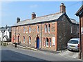
9
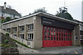
Launceston Old Fire Station 1
Launceston Old Fire Station 1, Westgate Street, Launceston, Cornwall. It has now been replaced by a new fire station in Hurdon Road (see Image). It replaced another fire station on Western Road (see Image)
Image: © Kevin Hale
Taken: 26 Sep 2004
0.16 miles
10
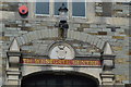
Westgate Centre and Cornwall Arms
Above the entrance to the former drill hall.
Image: © John M
Taken: 6 Sep 2014
0.16 miles