IMAGES TAKEN NEAR TO
Chapel Park Gardens, LAUNCESTON, PL15 7BT
Introduction
This page details the photographs taken nearby to Chapel Park Gardens, PL15 7BT by members of the Geograph project.
The Geograph project started in 2005 with the aim of publishing, organising and preserving representative images for every square kilometre of Great Britain, Ireland and the Isle of Man.

There are currently over 7.5m images from over14,400 individuals and you can help contribute to the project by visiting https://www.geograph.org.uk
Image Map
Images are licensed for reuse under creativecommons.org/licenses/by-sa/2.0
Notes
- Clicking on the map will re-center to the selected point.
- The higher the marker number, the further away the image location is from the centre of the postcode.
Image Listing (8 Images Found)
Images are licensed for reuse under creativecommons.org/licenses/by-sa/2.0
Image
Details
Distance
1

Texaco filling station and Co-op shop, Western Road, Launceston
Image: © David Smith
Taken: 15 Apr 2016
0.09 miles
2
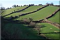
Green Valley by Launceston
Although surrounded on three sides by urban development, this valley remains purely agricultural. It stretches from the St Thomas district at the lower end to the Chapel district of Launceston at the upper end.
Image: © Tony Atkin
Taken: 25 Jan 2007
0.16 miles
3
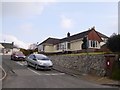
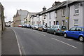
Bungalows in Woburn Road, Launceston
The cars are waiting on a short spur off Woburn Road, one of several residential streets in a small estate
Image: © David Smith
Taken: 15 Apr 2016
0.18 miles
4
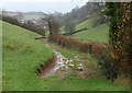
Footpath, Launceston
Footpath 520/1/1 runs along the valley shown in Image, below the remains of the town walls.
Image: © Derek Harper
Taken: 23 Nov 2009
0.18 miles
5
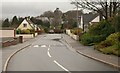
Woburn Road, Launceston
A suburban road southwest of the town centre, in the angle between Western Road and the A30.
Image: © Derek Harper
Taken: 23 Nov 2009
0.21 miles
6
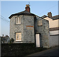
Chapple Tollhouse by Westgate Street, Launceston
Tollhouse by the A388, in the parish of Launceston (North Cornwall District), No. 34, Westgate Street.
Cornwall & Scilly HER.
HER Number: 176818 https://www.heritagegateway.org.uk/Gateway/Results_Single.aspx?uid=MCO52627&resourceID=1020
Surveyed
Milestone Society National ID: CW.LAU02
Image: © Alan Rosevear
Taken: 19 Feb 2008
0.23 miles
8
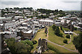
Launceston
Launceston roofscape from the castle keep
Image: © Richard Croft
Taken: 2 Jul 2010
0.25 miles